Cortland in Cortland County, New York — The American Northeast (Mid-Atlantic)
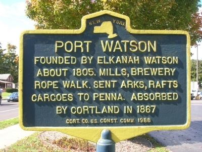
Port Watson
Founded by Elkanah Watson
About 1805. Mills, Brewery
Rope Walk. Sent Arks, Rafts
Cargoes to Penna. Absorbed
By Cortland in 1867
Erected 1988 by Cort. Co. U.S. Const. Comm.
Topics. This historical marker is listed in these topic lists: Industry & Commerce • Settlements & Settlers • Waterways & Vessels. A significant historical year for this entry is 1805.
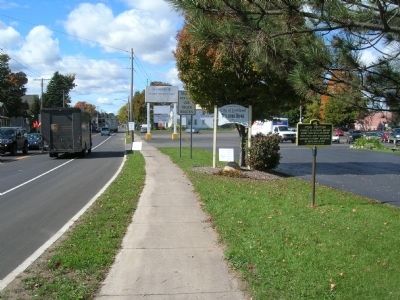
Location. 42° 35.918′ N, 76° 9.555′ W. Marker is in Cortland, New York, in Cortland County. Marker is on Port Watson Street (U.S. 11), on the right when traveling west. The marker is just within the City of Cortland on the right hand (north) side of Port Watson Street (NYS Rte. 41 & U.S.11) after crossing the Port Watson Street truss bridge which spans the Tioughnioga River. Touch for map. Marker is in this post office area: Cortland NY 13045, United States of America. Touch for directions.
Other nearby markers. At least 8 other markers are within walking distance of this marker. Headwaters of the Tioughnioga River (approx. 0.8 miles away); World War Memorial (approx. 0.9 miles away); Cortland County Vietnam War Memorial (approx. 0.9 miles away); Korean War Honored Dead (approx. 0.9 miles away); Cortland County World War I Honored Dead (approx. 0.9 miles away); Cortland County World War II Honored Dead (approx. 0.9 miles away); Cortland County Women Veterans Memorial (approx. 0.9 miles away); Cortland County Civil War Honored Dead (approx. 0.9 miles away). Touch for a list and map of all markers in Cortland.
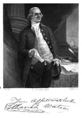
Regarding Port Watson. Elkanah Watson (January 22, 1758 – December 5, 1842) was a visionary traveler and writer, agriculturist and canal promoter. After the outbreak of hostilities in 1775, he served the Revolutionary cause as a courier for George Washington and other. He also carried dispatches to Benjamin Franklin in France. Towards promoting better agricultural practices, he organized the first county fair in the United States, at Pittsfield, Massachusetts, in 1810. In 1790 he settled in Albany, New York where he became a prominent businessman, land speculator, promoter of public works, and one of the founders of the Bank of Albany. In December 1791, he proposed that natural waterways could be used to create what later became the Erie Canal across New York State, to the New York State legislature. In 1792, with General Philip Schuyler, he formed a company to build locks and canals, starting with the Little Falls Canal.
While his endeavors were weighted on the public side, he did not entirely neglect his personal affairs. He made a canoe trip to Cayuga Lake, and subsequently bought parcels of land in the newly opened Military Tract. 'The Military Tract of Central New York' was land set aside to compensate New York’s soldiers after their participation in the Revolutionary War. Among these purchases was acreage along the Tioughnioga River just south of the intersection of its two branches. It was the Tioughnioga’s significance as the headwaters of the Chesapeake Bay that brought the first settlers to what is now Cortland County in 1791. The landing at the junction of the two branches of the river quickly became a center of great activity, particularly after Watson bought land in 1805 and laid out a checkerboard of streets and lots which soon became Port Watson, the leading port north of Binghamton for shipments to 'southern' markets. Here he planned and sold lots for his model town of Port Watson, which appeared on early maps and for a time actually exceeded nearby Cortland Village in population. He also owned property in the present towns of Cincinnatus, Cuyler, Homer, Marathon, Preble, Scott, Solon, Taylor and Truxton.
Before long Port Watson became the thriving community that is now the City of Cortland. Log rafts and "arks" began their voyages down river from the port, and boat yards, a tannery and a rope walk across the river marked the
site. Grain, potatoes, salted beef or pork, potash, gypsum and whiskey, as well as dried apples, maple sugar and other items produced in the county were exchanged in Harrisburg, York and Baltimore. Still other craft carried gypsum and salt from Ononodaga to Port Watson which was the head of navigation. Long before the Erie Canal, these waters were one of New York State’s primary commercial waterways.
The Tioughnioga River flows 400 miles south to the port of Havre de Grace, Maryland, the mouth of the Chesapeake, and it was not an uncommon sight in the early to mid 1800s to see "arks" loaded with local products floating down river to Baltimore. Warehouses were located at Port Watson where goods were stored until the water was high enough in the spring to float craft down the river. This usually occurred once or twice a year, in the early spring. Although the boats, some 90 feet long, had colorful names, they were short lived and were disassembled for their lumber once they reached their destination because it was impractical to return them to Port Watson.
Besides gypsum, great quantities of whiskey, grain, potatoes and other produce of this then wild country were sent down the river to Harrisburg and Baltimore. The odds of getting injured in some way on such a dangerous voyage were great, and even those experienced in handling these rafts and "arks" found it dangerous business. The following is an account of a river accident reported in The Cortland Republican of April 25, 1818:
Distressing Accident. - A few days since, Mr. Luman Rice, of this town, left Port Watson for Pennsylvania, with an ark laden with plaster. On the 14th inst. he endeavored to land at Northumberland. He coiled the rope, one end of which was attached to the ark, round his left arm and put it round a tree that leaned over the river - the other end was seized by his companions in the ark, where unfortunately his arm was caught in the rope, which cut it off instantly about half way between the elbow and the wrist. He fell into the river, and the current carried him a considerable distance from the shore. With one hand, and the bleeding stump that remained of the other arm, faint with the loss of blood, and almost exhausted, he succeeded in reaching the shore, after swimming eight or ten rods. It was found necessary to amputate his arm above the elbow - thus he was obliged to endure the pain of having it severed in two places.
Credits. This page was last revised on November 27, 2019. It was originally submitted on December 13, 2009, by Howard C. Ohlhous of Duanesburg, New York. This page has been viewed 1,683 times since then and 41 times this year. Photos: 1, 2, 3. submitted on December 13, 2009, by Howard C. Ohlhous of Duanesburg, New York. • Bill Pfingsten was the editor who published this page.


