Near Mechanicsburg in Hampshire County, West Virginia — The American South (Appalachia)
The Great Raid
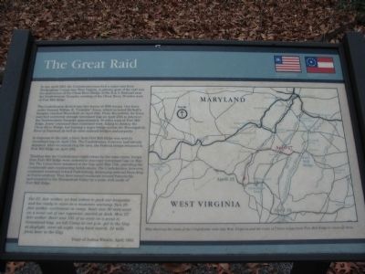
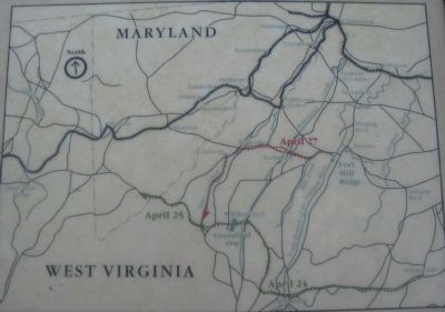
The Confederates divided into two forces of 3000 troops. One force under General William E. "Grumble" Jones which included McNeill's Rangers, reached Moorefield on April 24th. From Moorefield, the force marched northwest through Greenland Gap on April 25th to intersect the Northwestern Turnpike approximately 30 miles west of Fort Mill Ridge. Jones' command then continued west, failing to destroy the Cheat River Bridge, but burning a major bridge across the Monongahela River at Fairmont as well as other railroad bridges and property.
In response to the raid, a force from Fort Mill Ridge was sent to Greenland Gap on April 27th. The Confederates, however, had already departed. After reconnoitering the area, the Federal troops returned to Fort Mill Ridge on April 29th.
Thinking that the Confederates might return by the same route, troops from Fort Mill Ridge were ordered to reoccupy Greenland Gap on May 3rd. The Union force remained in the Gap until May 15th, patrolling the countryside and constructing fortifications. The Confederates, however, continued westward toward Parkersburg, destroying railroad lines deep in Union territory. They then turned southeast toward Sumersville and returned to the Shenandoah Valley by a route well south of Fort Mill Ridge.
Sat 25. fair wether. we had orders to pack our knapsacks and bee ready to move in a moments warning. Sun 26. fair wether. excitement in camp. thair was 80 men went on a scout out of our regement. started at dark. Mon 27. fair wether; thair was 185 of us weat on a scout to Greanland Gap. we left Camp at one p.m. got to the Gap at daylight. went all night. vary hard march. 21 mils from hear to the Gap.
Diary of Joshua Winters, April 1863.
Topics. This historical marker is listed in this topic list: War, US Civil. A significant historical month for this entry is March 1873.
Location. 39° 19.379′ N, 78° 47.665′ W. Marker is near Mechanicsburg, West Virginia, in Hampshire County. Marker can be reached from Fort Mill Ridge Park Road, on the right when traveling east. Located at trail stop 9 on the tour of Fort Mill Ridge Park. Touch for map. Marker is in this post office area: Burlington WV 26710, United States of America. Touch for directions.
Other nearby markers. At least 8 other markers are within walking distance of this marker. Abandonment of Fort Mill Ridge (within shouting distance of this marker); An Outpost in Enemy Territory (about 300 feet away, measured in a direct line); Interior of the Central Redoubt (about 400 feet away); Control of the Mechanicsburg Gap (about 400 feet away); Engagement with McNeill's Rangers (about 400 feet away); The Central Redoubt (about 400 feet away); Construction of Fort Mill Ridge (about 600 feet away); The Civil War in the South Branch Valley (about 600 feet away). Touch for a list and map of all markers in Mechanicsburg.
More about this marker. On the right is a Map showing the route of the Confederate raid into West Virginia and the route of Union troops from Fort Mill Ridge to intercept them.
Credits. This page was last revised on June 16, 2016. It was originally submitted on December 13, 2009, by Craig Swain of Leesburg, Virginia. This page has been viewed 1,021 times since then and 18 times this year. Photos: 1, 2, 3, 4. submitted on December 13, 2009, by Craig Swain of Leesburg, Virginia.


