Austin in Travis County, Texas — The American South (West South Central)
Del Valle Army Air Base
(Bergstrom Air Force Base)
Inscription.
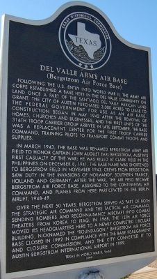
Following the U.S. entry into World War II, the Army Air Corps established a base here in the Del Valle community on land once a part of the Santiago del Valle Mexican land grant. The City of Austin purchased 3,000 acres to lease to the federal government for use as an air base. Construction began in May 1942 after the removal of homes, churches and businesses, and the first units of the 316th Troop Carrier Group arrived in late September. The base was a replacement center for the First Troop Carrier Command, training pilots to transport combat troops and supplies.
In March 1943, the base was renamed Bergstrom Army Air Field to honor Captain John August Earl Bergstrom, Austin's first casualty of war; he was killed at Clark Field in the Philippines on December 8, 1941. The base name was shortened to Bergstrom Field in November 1943. Crews from Bergstrom saw duty in the invasions of Normandy, southern France, Holland and Germany. After the war, the air field became Bergstrom Air Force Base, assigned to the Continental Air Command, and planes from here participated in the Berlin Airlift, 1948-49.
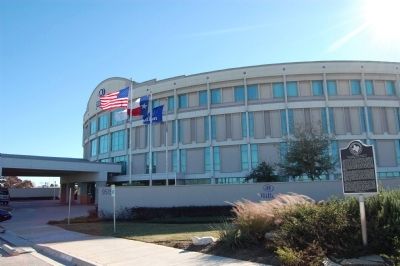
Over the next 50 years, Bergstrom served as part of both the Strategic Air Command and the Tactical Air Command, sending bombers and reconnaissance aircraft into combat theaters from Korea to Iraq. In 1968, the 12th Air Force moved its headquarters here to a newly completed circular building, nicknamed the "Roundagon." Bergstrom Air Force Base closed in 1992 in compliance with the Base Realignment and Closure Commission, and the city converted it to Austin-Bergstrom International Airport in 1999.
Erected 2005 by Texas Historical Commission. (Marker Number 13778.)
Topics. This historical marker is listed in these topic lists: Military • Notable Places. A significant historical month for this entry is March 1943.
Location. 30° 12.728′ N, 97° 39.829′ W. Marker is in Austin, Texas, in Travis County. Marker is on Hotel Drive south of Spirit of Texas Drive, on the right when traveling south. Touch for map. Marker is in this post office area: Austin TX 78719, United States of America. Touch for directions.
Other nearby markers. At least 8 other markers are within 4 miles of this marker, measured as the crow flies. Richard Overton Healing Garden (approx. 1.7 miles away); Burditt Prairie Cemetery (approx. 2.3 miles away); Moore’s Crossing Bridge (approx. 3 miles away); Collins Cemetery (approx. 3.7 miles away); The Original Townsite of Montopolis (approx. 3.7 miles away); John Williams and Howell Haggett (approx. 3.9 miles away); Josephus Hornsby (approx. 3.9 miles away); Site of Home of Reuben Hornsby (approx. 4 miles away). Touch for a list and map of all markers in Austin.
Also see . . .
Wikipedia: Berstrom Air Force Base. (Submitted on December 19, 2009, by Keith Peterson of Cedar Park, Texas.)
Credits. This page was last revised on February 1, 2023. It was originally submitted on December 19, 2009, by Keith Peterson of Cedar Park, Texas. This page has been viewed 2,515 times since then and 129 times this year. Photos: 1, 2. submitted on December 19, 2009, by Keith Peterson of Cedar Park, Texas. 3, 4. submitted on October 11, 2013, by Richard Denney of Austin, Texas. • Bill Pfingsten was the editor who published this page.


