Surry in Surry County, Virginia — The American South (Mid-Atlantic)
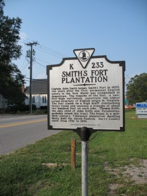
Smith’s Fort Plantation
Erected 1999 by Department of Historic Resources. (Marker Number K233.)
Topics and series. This historical marker is listed in these topic lists: Agriculture • Colonial Era • Forts and Castles • Native Americans • Settlements & Settlers. In addition, it is included in the Virginia Department of Historic Resources (DHR) series list. A significant historical year for this entry is 1609.
Location. 37° 8.18′ N, 76° 50.117′ W. Marker is in Surry, Virginia, in Surry County. Marker is on Rolfe Road (Virginia Route 10) south of Main Street (Virginia Route 10), on the left when traveling west. Touch for map. Marker is in this post office area: Surry VA 23883, United States of America. Touch for directions.
Other nearby markers. At least 8 other markers are within 2 miles of this marker, measured as the crow flies. Chanco (about 500 feet away, measured in a direct line); Capt. Jacob Faulcon, C.S.A. (about 600 feet away); Surry County Confederate Monument (about 600 feet away); Surry County War Memorial (about 600 feet away); Surry County WWII Veterans Memorial (approx. 0.2 miles away); Organization of the Christian Church (approx. one mile away); Pleasant Point (approx. 1.6 miles away); Chippokes Plantation (approx. 1.7 miles away). Touch for a list and map of all markers in Surry.
Credits. This page was last revised on January 9, 2020. It was originally submitted on September 23, 2007, by Laura Troy of Burke, Virginia. This page has been viewed 1,892 times since then and 39 times this year. Photo 1. submitted on September 23, 2007, by Laura Troy of Burke, Virginia. • J. J. Prats was the editor who published this page.
Editor’s want-list for this marker. A wide shot of the marker and its surroundings. Photos of the remains of the Smith's Fort Earthworks. • Can you help?
