Surry in Surry County, Virginia — The American South (Mid-Atlantic)
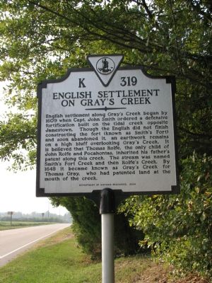
English Settlement on Gray’s Creek
Erected 2004 by Department of Historic Resources. (Marker Number K-319.)
Topics and series. This historical marker is listed in these topic lists: Colonial Era • Settlements & Settlers. In addition, it is included in the Virginia Department of Historic Resources (DHR) series list. A significant historical year for this entry is 1609.
Location. 37° 8.037′ N, 76° 53.166′ W. Marker is in Surry, Virginia, in Surry County. Marker is at the intersection of Colonial Trail West (Virginia Route 10) and Hollybush Road (County Route 618), on the right when traveling north on Colonial Trail West. Touch for map. Marker is in this post office area: Surry VA 23883, United States of America. Touch for directions.
Other nearby markers. At least 8 other markers are within 3 miles of this marker, measured as the crow flies. Pace’s Paines (a few steps from this marker); Southwark Parish Churches (about 300 feet away, measured in a direct line); Glebe House of Southwark Parish (approx. 0.3 miles away); Organization of the Christian Church (approx. 2.3 miles away); Surry County WWII Veterans Memorial (approx. 2.8 miles away); Smith’s Fort Plantation (approx. 2.8 miles away); Chanco (approx. 2.8 miles away); Surry County War Memorial (approx. 2.8 miles away). Touch for a list and map of all markers in Surry.
More about this marker. This marker sits with K-224 and across the street from K-229.
Credits. This page was last revised on June 16, 2016. It was originally submitted on September 24, 2007, by Laura Troy of Burke, Virginia. This page has been viewed 2,658 times since then and 93 times this year. Photo 1. submitted on September 24, 2007, by Laura Troy of Burke, Virginia. • J. J. Prats was the editor who published this page.
