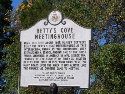
Near Easton in Talbot County, Maryland — The American Northeast (Mid-Atlantic)
Betty’s Cove Meetinghouse
Erected by Talbot County Council, Historical Society of Talbot County, Third Haven Monthly Meeting of Friends, Maryland Historical Society.
Topics and series. This historical marker is listed in this topic list: Notable Buildings. In addition, it is included in the Quakerism series list. A significant historical year for this entry is 1665.
Location. 38° 47.018′ N, 76° 7.017′ W. Marker is near Easton, Maryland, in Talbot County. Marker is at the intersection of St. Michaels Road (Maryland Route 33) and Unionville Road (Maryland Route 370), on the right when traveling west on St. Michaels Road. Touch for map. Marker is in this post office area: Easton MD 21601, United States of America. Touch for directions.
Other nearby markers. At least 8 other markers are within 3 miles of this marker, measured as the crow flies. Site of “The Rest” (approx. 0.7 miles away); The “Mannour of Ratcliffe” (approx. 1.3 miles away); Bracing for an Attack (approx. 1.6 miles away); William Penn (approx. 1.7 miles away); Fausley (approx. 2 miles away); Unionville (approx. 2 miles away); Union Soldiers (approx. 2.2 miles away); a different marker also named Unionville (approx. 2.2 miles away). Touch for a list and map of all markers in Easton.
Credits. This page was last revised on June 16, 2016. It was originally submitted on October 26, 2007, by Bill Pfingsten of Bel Air, Maryland. This page has been viewed 2,334 times since then and 57 times this year. Photo 1. submitted on October 26, 2007, by Bill Pfingsten of Bel Air, Maryland. • J. J. Prats was the editor who published this page.
