Charlestown in Washington County, Rhode Island — The American Northeast (New England)
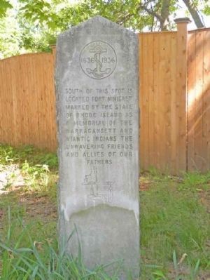
Fort Ninigret Marker
Inscription.
South of this spot is located Fort Ninigret marked by the State of Rhode Island as a memorial of the Narragansett and Niantic Indians. The unwavering friends and allies of our fathers.
Erected 1936.
Topics. This historical marker is listed in these topic lists: Colonial Era • Forts and Castles • Native Americans.
Location. 41° 23.053′ N, 71° 38.804′ W. Marker is in Charlestown, Rhode Island, in Washington County. Marker is at the intersection of Old Post Road (U.S. 1A) and Fort Ninigret Road, on the right when traveling east on Old Post Road. This Marker is located on the east side of the beginning of Fort Ninigret Road which leads to another associated marker. Touch for map. Marker is at or near this postal address: 4531 Old Post Rd, Charlestown RI 02813, United States of America. Touch for directions.
Other nearby markers. At least 8 other markers are within 8 miles of this marker, measured as the crow flies. Fort Ninigret (approx. ¼ mile away); Charlestown Naval Auxiliary Landing Field Memorial (approx. 1.2 miles away); Grumman F6F-5N Hellcat Crash (approx. 1.2 miles away); Liberty Tree Memorial (approx. 1.3 miles away); General Joseph Stanton Monument (approx. 4 miles away); The Great Swamp Fight (approx. 6.4 miles away); Samuel Ward Birthplace Site (approx. 7 miles away); First Seventh Day Baptist Church of Hopkinton (approx. 7.8 miles away). Touch for a list and map of all markers in Charlestown.
Credits. This page was last revised on December 5, 2020. It was originally submitted on June 1, 2010, by Dwight C. Brown Jr. of Bradford, Rhode Island. This page has been viewed 1,174 times since then and 14 times this year. Last updated on June 18, 2010, by Kenneth Zirkel of Seekonk, Massachusetts. Photo 1. submitted on June 1, 2010, by Dwight C. Brown Jr. of Bradford, Rhode Island. • Kevin W. was the editor who published this page.
