Near Chester Gap in Rappahannock County, Virginia — The American South (Mid-Atlantic)
Minding the Gaps
“A very fatal oversight”
— Gettysburg Campaign —
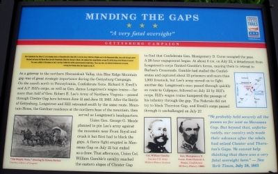
As a gateway to the northern Shenandoah Valley, this Blue Ridge Mountain gap was of great strategic importance during the Gettysburg Campaign. On the march north to Pennsylvania, Confederate Gens. Richard S. Ewell’s and A.P. Hill’s corps, as well as Gen. James Longstreet’s wagon trains—far more than half of Gen. Robert E. Lee’s Army of Northern Virginia—passed through Chester Gap here between June 11 and June 19, 1863. After the Battle of Gettysburg, Longstreet and Hill retreated south by the same route. Mountain Home, the Gardner residence at the northern base of the mountain, then served as Longstreet’s headquarters.
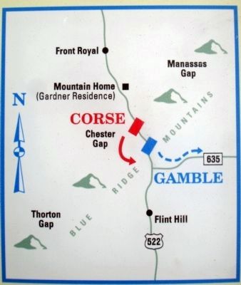
Union Gen. George G. Meade planned to pin Lee’s army against the mountain near Front Royal and crush it but first had to block the gaps. A fierce fight erupted in Manassas Gap on July 21 but ended as a draw. That afternoon, Union Col. William Gamble’s cavalry reached the eastern slopes of Chester Gap to find that Confederate Gen. Montgomery D. Corse occupied the pass. A 26-hour engagement began. At about 6 P.M. on July 22, a detachment from Longstreet’s corps flanked Gamble’s forces causing them to retreat to Barbee’s Crossroads. Gamble had stalled the Confederates and captured about 23 prisoners and more than 1,000 livestock, but Lee’s army moved on to fight another day. Longstreet’s men passed through quickly en route to Culpeper, followed on July 23 by Hill’s corps. Hill’s wagon trains hampered the passage of his infantry through the gap. The Federals did not try to block Thornton’s Gap, and Ewell’s corps passed through it unchallenged on July 27.
“We probably held securely all the passes as far west as Manassas Gap. But beyond that, unfortunately, our cavalry only made their advance after the rebels had seized Chester and Thornton’s Gaps. We cannot help thinking that there was a very fatal oversight here.” — New York Times, July 28, 1863
Erected by Virginia Civil War Trails.
Topics and series. This historical marker is listed in this topic list: War, US Civil. In addition, it is included in the Virginia Civil War Trails series list. A significant historical month for this entry is May 1863.
Location. 38° 51.716′ N, 78° 7.905′ W. Marker is near Chester Gap, Virginia, in Rappahannock County. Marker is on Chester Gap Road, on the left when traveling south. The marker is located Route 665 near its northern intersection with Route 522. Touch for map. Marker is in this post office area: Chester Gap VA 22623, United States of America. Touch for directions.
Other nearby markers. At least 8 other markers are within 5 miles of this marker, measured as the crow flies. Chester Gap (here, next to this marker); Warren County / Rappahannock County (within shouting distance of this marker); Gettysburg Campaign (within shouting distance of this marker); Albert G. Willis (approx. 1.7 miles away); Battle of Manassas Gap (approx. 3.9 miles away); No Park is an Island (approx. 4.2 miles away); The Massanutten (approx. 4.2 miles away); Camp Dismal Hollow (approx. 4.2 miles away). Touch for a list and map of all markers in Chester Gap.
More about this marker. On the lower left of the marker is a drawing captioned “The Supply Train,” drawing by Edwin Forbes Courtesy Library of Congress. On the lower right of the marker are two photos captioned Col. William Gamble Courtesy U.S. Army Military History Institute and Gen. Montgomery D. Corse, from Clement A. Evans, Confederate Military History (1899). On the upper right of the marker is a map of the area around Chester Gap indicating troop positions and movements described in the marker text.
Credits. This page was last revised on June 16, 2016. It was originally submitted on June 19, 2010. This page has been viewed 1,528 times since then and 47 times this year. Photos: 1, 2, 3. submitted on June 19, 2010. • Craig Swain was the editor who published this page.


