Ridgefield in Fairfield County, Connecticut — The American Northeast (New England)
Ridgefield's Colonial Plans
Ridgefield, Connecticut
— The Museum in the Streets —

Photographed By Michael Herrick, June 2, 2010
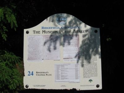
1. Ridgefield's Colonial Plans Marker
The caption to the left-hand photo on the marker: Front page of the "Bill of sale" of "a tract of land" sold by the Ramapo Indians to the Proprietors, September 30, 1708 (RLR, vol. 1, p-1)
The caption to the rigt-hand photo on the marker: Thomas Hauley's Mark for his Cattle and Swine . . . Swallow tail or fork Y on ye off. Ear . . . and for his horse kind T.H. on ye near buttock . . .
The bottom photo lists the original Proprietors of Ridgefield
The caption to the rigt-hand photo on the marker: Thomas Hauley's Mark for his Cattle and Swine . . . Swallow tail or fork Y on ye off. Ear . . . and for his horse kind T.H. on ye near buttock . . .
The bottom photo lists the original Proprietors of Ridgefield
The First Recorded Plan for settlement was in 1697 when a group of Congregationalists primarily from Norwalk petitioned "to purchase of the Indians a certain tract of land lying about 14 miles northward of the town of Norwalk to settle a plantation there." On May 13, 1708 a petition for purchase of the land was submitted to the General Assembly in Hartford. On September 30, 1708 the purchase was formalized and plans for settlement were being drawn up. Each of the original Proprietors received two and a half acres facing the main street, and later an additional five acres were added to the rear of each lot. The meetinghouse and town green were placed in the center of these plots and a cemetery was located at the southern end, (part of the cemetery remains off Creamery Lane.) The outlying land was divided in 1709 into meadows for planting, mowing and grazing.
A liberty pole was erected near the meetinghouse shortly after Ridgefield entered the War for Independence. It is said that the pole was made from an old buttonwood tree that grew near (what is today) Market Street. A whipping post was located nearby. Tradition tells us that Abijah Resseguie; proprietor of the Resseguie Hotel (now the Keeler Tavern Museum) was a witness to the last flogging, which took place sometime in the 19th century.
Erected by The Museum in the Streets®. (Marker Number 24.)
Topics and series. This historical marker is listed in these topic lists: Colonial Era • Settlements & Settlers. In addition, it is included in the The Museum in the Streets®: Ridgefield, Connecticut series list. A significant historical month for this entry is May 1777.
Location. 41° 16.525′ N, 73° 29.833′ W. Marker is in Ridgefield, Connecticut, in Fairfield County. Marker is at the intersection of Main Street (Connecticut Route 35) and Branchville Road (Connecticut Route 102), on the right when traveling north on Main Street. Touch for map. Marker is in this post office area: Ridgefield CT 06877, United States of America. Touch for directions.
Other nearby markers. At least 8 other markers are within walking distance of this marker. Ridgefield Veterans Monument (within shouting distance of this marker); The Town Common and Hauley House (within shouting distance of this marker); Rev. Thomas Hawley House (about 300 feet away, measured in a direct line); Benedict Arnold's Betrayal and Lieutenant Joshua King (about 500 feet away); The Walter Lamb Furniture Collection by Brown Jordan (about 500 feet away); Aldrich Contemporary Art Museum Land Acknowledgement (about 600 feet away); a different marker also named The Walter Lamb Furniture Collection by Brown Jordan (about 600 feet away); Cecile Abish (b. 1926, New York, NY) (approx. 0.2 miles away). Touch for a list and map of all markers in Ridgefield.
Related markers. Click here for a list of markers that are related to this marker. Take the Museum in the Streets Walking Tour in Ridgefield, Connecticut.
Credits. This page was last revised on November 25, 2021. It was originally submitted on June 20, 2010, by Michael Herrick of Southbury, Connecticut. This page has been viewed 1,117 times since then and 28 times this year. Photos: 1, 2. submitted on June 20, 2010, by Michael Herrick of Southbury, Connecticut.
