Hanover in Hanover County, Virginia — The American South (Mid-Atlantic)
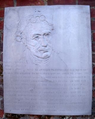
Patrick Henry
May 29, 1736 – June 6, 1799
Erected 1979 by Hanover Ruritan Club.
Topics. This historical marker is listed in these topic lists: Agriculture • Colonial Era • Patriots & Patriotism. A significant historical month for this entry is April 1778.
Location. 37° 45.786′ N, 77° 21.988′ W. Marker is in Hanover, Virginia, in Hanover County. Marker can be reached from the intersection of Hanover Courthouse Road (U.S. 301) and Library Drive. Touch for map. Marker is in this post office area: Hanover VA 23069, United States of America. Touch for directions.
Other nearby markers. At least 8 other markers are within walking distance of this marker. Hanover Courthouse (within shouting distance of this marker); a different marker also named Hanover Courthouse (within shouting distance of this marker); Hanover Confederate Soldiers Monument (within shouting distance of this marker); The Fields Family (about 300 feet away, measured in a direct line); Hanover Tavern (about 300 feet away); a different marker also named Hanover Tavern (about 400 feet away); a different marker also named Hanover Tavern (about 400 feet away); The Colonial River Road (approx. 0.9 miles away). Touch for a list and map of all markers in Hanover.
Also see . . . The Parson's Cause Foundation. (Submitted on July 5, 2010, by Bernard Fisher of Richmond, Virginia.)
Credits. This page was last revised on December 25, 2019. It was originally submitted on July 5, 2010, by Bernard Fisher of Richmond, Virginia. This page has been viewed 940 times since then and 15 times this year. Photos: 1, 2, 3. submitted on July 5, 2010, by Bernard Fisher of Richmond, Virginia.


