Near Waterloo in Lauderdale County, Alabama — The American South (East South Central)
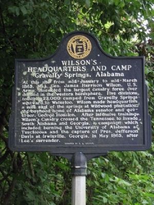
Wilson's Headquarters and Camp
Gravelly Springs, Alabama
At this site from mid-January to mid-March 1865, Maj. Gen. James Harrison Wilson, U.S. Army, assembled the largest cavalry force ever massed in the western hemisphere. Five divisions totaling 22,000 camped from Gravelly Springs westward to Waterloo. Wilson made headquarters a mile east of the springs at Wildwood plantation, the boyhood home of Alabama senator and governor, George Houston. After intensive training Wilson's Cavalry crossed the Tennessee to invade South Alabama and Georgia, a campaign which included burning the University of Alabama at Tuscaloosa and the capture of Pres. Jefferson Davis at Irwinville, Georgia, in May 1865, after Lee's surrender.
Donated by C. L. Culver
Erected by Florence Historic Board of Florence Alabama.
Topics. This historical marker is listed in this topic list: War, US Civil. A significant historical month for this entry is May 1865.
Location. 34° 53.072′ N, 87° 54.258′ W. Marker is near Waterloo, Alabama, in Lauderdale County. Marker is at the intersection of County Route 14 and County Route 2, on the right when traveling north on County Route 14. Touch for map. Marker is in this post office area: Waterloo AL 35677, United States of America. Touch for directions.
Other nearby markers. At least 8 other markers are within 4 miles of this marker, measured as the crow flies. General John Coffee (approx. 1.8 miles away); Tiny Jewels of the Air (approx. 1.8 miles away); Rock Spring (approx. 1.8 miles away); Macedonia Church of Christ (approx. 3.1 miles away); Driven Up The Waters (approx. 3.2 miles away); Wet, Wild, and Wonderful (approx. 3.9 miles away); Welcome! (approx. 3.9 miles away); Safe Crossing (approx. 3.9 miles away). Touch for a list and map of all markers in Waterloo.
Also see . . .
1. Gravelly Springs. Shoals History website entry (Submitted on August 15, 2022, by Larry Gertner of New York, New York.)
2. Wilson’s Raid. New Georgia Encyclopedia website entry (Submitted on November 26, 2023, by Larry Gertner of New York, New York.)
Credits. This page was last revised on November 26, 2023. It was originally submitted on July 7, 2010, by Sandra Hughes Tidwell of Killen, Alabama, USA. This page has been viewed 3,998 times since then and 98 times this year. Photos: 1. submitted on July 7, 2010, by Sandra Hughes Tidwell of Killen, Alabama, USA. 2. submitted on November 26, 2023, by Larry Gertner of New York, New York. • Craig Swain was the editor who published this page.

