Rock Island in Rock Island County, Illinois — The American Midwest (Great Lakes)
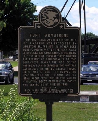
Fort Armstrong
Erected 1965 by Rock Island County Historical Society and The Illinois State Historical Society.
Topics and series. This historical marker is listed in these topic lists: Forts and Castles • Settlements & Settlers. In addition, it is included in the Black Hawk War, and the Illinois State Historical Society series lists. A significant historical date for this entry is May 4, 1836.
Location. 41° 31.062′ N, 90° 33.88′ W. Marker is on Rock Island, Illinois, in Rock Island County. Marker can be reached from Rodman Avenue, 0.1 miles Government Bridge, on the right when traveling east. The marker is located on the grounds of the U.S. Army Rock Island Arsenal on Arsenal Island. Access is through the Davenport Gate with photo ID. The marker is in front of the Mississippi River Visitor's Center building at Lock and Dam 15. Touch for map. Marker is in this post office area: Rock Island IL 61299, United States of America. Touch for directions.
Other nearby markers. At least 8 other markers are within walking distance of this marker. Fort Armstrong Sesquicentennial (about 400 feet away, measured in a direct line); Site of Fort Armstrong (about 500 feet away); Fort Armstrong Cemetery Boulders (about 600 feet away); John Gale & Richard M. Coleman (about 600 feet away); First Railroad Bridge Across the Mississippi (approx. 0.4 miles away in Iowa); Hose Station No. 1 (approx. half a mile away in Iowa); Farnam & 5th Street (approx. half a mile away in Iowa); First Chiropractic Adjustment (approx. 0.6 miles away in Iowa). Touch for a list and map of all markers in Rock Island.
Also see . . . The History Of Rock Island Arsenal: Fort Armstrong Era. Garrison website (Submitted on July 18, 2010, by PaulwC3 of Northern, Virginia.)
Credits. This page was last revised on November 5, 2020. It was originally submitted on July 18, 2010, by PaulwC3 of Northern, Virginia. This page has been viewed 2,170 times since then and 101 times this year. Photos: 1, 2, 3. submitted on July 18, 2010, by PaulwC3 of Northern, Virginia.
Editor’s want-list for this marker. Photo of the 1916 replica blockhouse • Can you help?


