Downtown in Hampton, Virginia — The American South (Mid-Atlantic)
Hampton Is Burned
"… a bright light over by the bay."
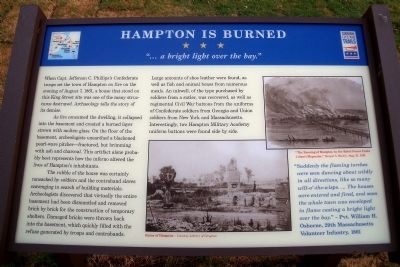
When Capt. Jefferson C. Phillips’s Confederate troops set the town of Hampton on fire on the evening of August 7, 1861, a house that stood on this King Street site was one of the many structures destroyed. Archaeology tells the story of its demise.
As fire consumed the dwelling, it collapsed into the basement and created a burned layer strewn with molten glass. On the floor of the basement, archeologists unearthed a blackened pearl-ware pitcher—fractured, but brimming with ash and charcoal. This artifact alone probably best represents how the inferno altered the lives of Hampton’s inhabitants.
The rubble of the house was certainly ransacked by soldiers and the contraband slaves scavenging in search of building materials. Archeologists discovered that virtually the entire basement had been dismantled and removed brick by brick for the construction of temporary shelters. Damaged bricks were thrown back into the basement, which quickly filled with the refuse generated by troops and contrabands.
Large amounts of shoe leather were found, as well as fish and animal bones from numerous meals. An inkwell, of the type purchased by soldiers from a sutler, was recovered, as well as regimental Civil War buttons from the uniforms of Confederate soldiers from Georgia and Union soldiers from New York and Massachusetts. Interestingly, two Hampton Military Academy uniform buttons were found side by side.
“Suddenly the flaming torches were seen dancing about wildly in all directions, like so many will-o’-the-wisps. … The houses were entered and fired, and soon the whole town was enveloped in flame casting a bright light over the bay.” – Pvt. William H. Osborne, 29th Massachusetts Volunteer Infantry, 1861
Erected by Virginia Civil War Trails.
Topics and series. This historical marker is listed in these topic lists: Notable Events • War, US Civil. In addition, it is included in the Virginia Civil War Trails series list. A significant historical year for this entry is 1861.
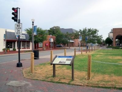
Location. Marker has been permanently removed. It was located near 37° 1.487′ N, 76° 20.627′ W. Marker was in Hampton, Virginia. It was in Downtown. Marker was at the intersection of Settlers Landing Road (U.S. 60) and South King Street, on the right when traveling west on Settlers Landing Road. A building now stands in the spot. Touch for map. Marker was at or near this postal address: 655 Settlers Landing Rd, Hampton VA 23669, United States of America.
We have been informed that this sign or monument is no longer there and will not be replaced. This page is an archival view of what was.
Other nearby markers. At least 8 other markers are within walking distance of this location. Twentieth-Century Hampton (within shouting distance of this marker); Langley Field: Creating an Air Force (within shouting distance of this marker); Seventeenth-Century Hampton (within shouting distance of this marker); Langley Field: Discovering Aerospace (within shouting distance of this marker); Ninteenth-Century Hampton (within shouting distance of this marker); Katherine Coleman Goble Johnson (within shouting distance of this marker); Eighteenth-Century Hampton (within shouting distance of this marker); The Magnolia Tree Inn (within shouting distance of this marker). Touch for a list and map of all markers in Hampton.
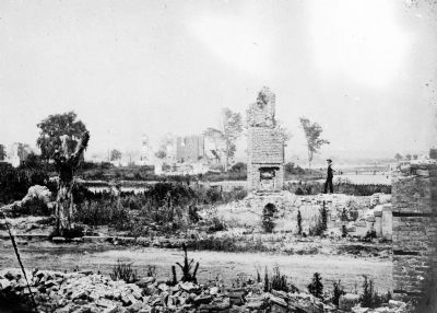
More about this marker. On the bottom center is a photograph of the “Ruins of Hampton” – Courtesy Library of Congress
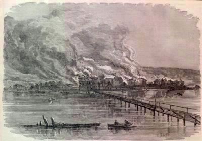
On the upper right is center is an illustration of “The Burning of Hampton by the Rebel Forces under Colonel Magruder,” Harper’s Weekly, Aug.31, 1861

circa 1865
3. Ruins at Hampton, Virginia showing chimneys, and man standing
Library of Congress [LC-USZ62-103066]
Click for more information.
Click for more information.

Photographed By Harper's Weekly, August 31, 1861
4. The Burning of Hampton
Harper's Weekly illustration.
Click for more information.
Click for more information.
Credits. This page was last revised on March 29, 2023. It was originally submitted on August 1, 2010, by Bernard Fisher of Richmond, Virginia. This page has been viewed 1,753 times since then and 66 times this year. Last updated on March 28, 2023, by James Dean of Chesterfield, Virginia. Photos: 1, 2, 3, 4. submitted on August 1, 2010, by Bernard Fisher of Richmond, Virginia. • Devry Becker Jones was the editor who published this page.

