Near Trempealeau in Trempealeau County, Wisconsin — The American Midwest (Great Lakes)
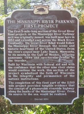
The Mississippi River Parkway:
First Project
Built by Wisconsin with federal aid and with the confidence that the other nine river states would continue the work, this section of the project symbolized the faith of Wisconsin in the integrity and permanence of the nation's institutions.
The completion of the first part of the 2,000 mile project provided tangible evidence that the concept of a pleasurable riverside highway along the banks of the Mississippi River, from its source to the sea, would be realized.
Erected 1994 by the Wisconsin Historical Society. (Marker Number 8.)
Topics and series. This historical marker is listed in these topic lists: Roads & Vehicles • Waterways & Vessels. In addition, it is included in the Wisconsin Historical Society series list. A significant historical year for this entry is 1953.
Location. 44° 0.185′ N, 91° 25.533′ W. Marker is near Trempealeau, Wisconsin, in Trempealeau County. Marker can be reached from East 3rd Street / Great River Road (State Highway 35) 0.4 miles east of Chase Street (County Highway K), on the right when traveling east. Marker can be reached from the parking lot of the Great River State Trail; marker is along the trail. Touch for map. Marker is in this post office area: Trempealeau WI 54661, United States of America. Touch for directions.
Other nearby markers. At least 8 other markers are within 6 miles of this marker, measured as the crow flies. James Allen Reed / Trempealeau (approx. 0.9 miles away); Great River Bluffs (approx. 2 miles away in Minnesota); French Post (approx. 2½ miles away); Brady's Bluff (approx. 2.7 miles away); The Geology of Perrot State Park (approx. 3.4 miles away); Historic Lake Labelle (approx. 3.8 miles away in Minnesota); Pickwick Mill (approx. 3.9 miles away in Minnesota); Gale College Historic District (approx. 6 miles away). Touch for a list and map of all markers in Trempealeau.
Credits. This page was last revised on October 25, 2020. It was originally submitted on October 14, 2009, by Keith L of Wisconsin Rapids, Wisconsin. This page has been viewed 1,019 times since then and 20 times this year. Last updated on August 2, 2010, by William J. Toman of Green Lake, Wisconsin. Photos: 1, 2. submitted on October 14, 2009, by Keith L of Wisconsin Rapids, Wisconsin. • Kevin W. was the editor who published this page.

