Near Newton Grove in Johnston County, North Carolina — The American South (South Atlantic)
Naval Stores
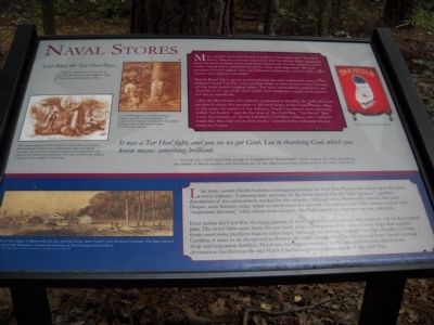
God Bless the Tar Heel Boys
- Quote attributed to Gen. R. E. Lee in R. B. Creecy’s Grandfather Tales of North Carolina History, 1901.
Many people know that North Carolina is nicknamed the “Tar Heel State,” but not everyone may know that the phrase likely originated from North Carolina’s most important nineteenth-century industry, naval stores. Naval stores included tar, pitch, rosin, and turpentine. All were produced from longleaf pine sap and most commonly used to make ships’ beams and riggings watertight.
British Royal Navy agents realized during the early eighteenth century that colonial North Carolina was a perfect place to harvest naval stores because of the many native longleaf pines. The trees’ tremendous girth led to an abundance of sap, while their height and straightness made them perfect for use as mastheads.
After the Revolution, the industry continued to flourish. By 1840, the state produced ninety-five percent of all naval stores in the United States. Due to the unsavory nature of the industry, North Carolinians were derisively called “tar boilers” and, by the time of the Civil War, “Tar Heels.” But soon, the tenacity of North Carolina’s Civil War soldiers, who “stuck in battle like they had tar on their heels,” converted the nickname from a tease to a boast.
It was a Tar Heel fight, as you see we got Genl. Lee to thanking God, which you know means something brilliant.
- Excerpt of a letter from Maj. Joseph A. Engelhard to “Friend Ruff” dated August 28, 1864, describing the Battle of Reams Station and including one of the oldest surviving written uses of the term “Tar Heel.”
Like many eastern North Carolina communities before the Civil War, Bentonville relied upon the naval stores industry. Contemporary accounts of the battle placed it in the “pine barrens,” a perfect description of the environment needed for the industry. Although most Bentonville citizens, like John Harper, were farmers, many relied on naval stores for income. According to the 1860 census, several were “turpentine laborers,” while others were coopers, who built barrels to store raw sap, tar, and pitch.
Even before the Civil War, the large amount of resin collected had begun to take a serious toll on the longleaf pine. The worst blow came from the war itself, which demonstrated the value of iron ships that required fewer naval store products than wooden ships. Although the industry lingered for a few decades in North Carolina, it came to an abrupt end in Bentonville when fleeing Confederates burned John Hood’s carriage shop and turpentine distillery. Hood was the largest employer in the area, and the loss added to the devastation that Bentonville and North Carolina experienced as a result of the Civil War.
Topics. This historical marker is listed in these topic lists: Industry & Commerce • War, US Civil. A significant historical year for this entry is 1901.
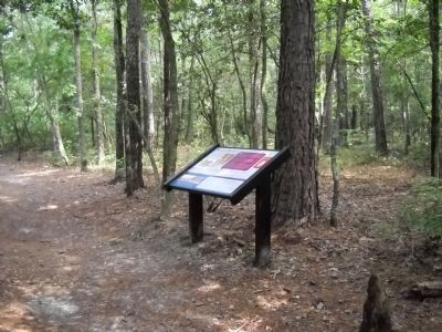
Location. 35° 18.331′ N, 78° 19.295′ W. Marker is near Newton Grove, North Carolina, in Johnston County. Marker can be reached from Mill Creek Church Road, on the right when traveling north. Marker is located on the Bentonville Battlefield, along the walking trail starting near the visitor center. Touch for map. Marker is in this post office area: Newton Grove NC 28366, United States of America. Touch for directions.
Other nearby markers. At least 8 other markers are within walking distance of this marker. Michigan Engineers Original Field Works (about 400 feet away, measured in a direct line); North Carolinians at the Battle of Bentonville (approx. 0.2 miles away); Texas (approx. ¼ mile away); North Carolina Monument (approx. ¼ mile away); Bentonville Union Soldiers Memorial (approx. ¼ mile away); Federal Earthworks (approx. ¼ mile away); Confederate Dead Monument (approx. ¼ mile away); Honoring the Dead of the Battle of Bentonville (approx. ¼ mile away).
More about this marker. The upper left of the marker features an “1855 engraving from Ballou’s Pictorial Drawing-Room Companion, illustrating the 19th-century national perception of North Carolina. An overseer is shown watching enslaved workers tap pines for the naval stores industry. The state seal from the period is located in the middle of the image.” Next to this is a “Circa 1890 image of a worker tapping a longleaf pine for crude turpentine in neighboring Samson County. The irreparable damage done to the tree is evident. - North Carolina Archives.” At the bottom left is a “Sketch of the Village of Bentonville the day after the battle, from Frank Leslie’s Illustrated Newspaper. The large amount of smoke in the illustration is from the burning of Hood’s turpentine distillery. Courtesy of the North Carolina Collection, University of North Carolina at Chapel Hill.” Also on the marker is a Tar Heels poster from the North Carolina Museum of History.
Related markers. Click here for a list of markers that are related to this marker. Take a tour of the Roadside Exhibits erected on the Battle of Bentonville.
Credits. This page was last revised on May 12, 2023. It was originally submitted on August 13, 2010, by Bill Coughlin of Woodland Park, New Jersey. This page has been viewed 1,118 times since then and 22 times this year. Last updated on May 9, 2023, by Michael Buckner of Durham, North Carolina. Photos: 1, 2, 3. submitted on August 13, 2010, by Bill Coughlin of Woodland Park, New Jersey. • J. Makali Bruton was the editor who published this page.


