Mossy in Fayette County, West Virginia — The American South (Appalachia)
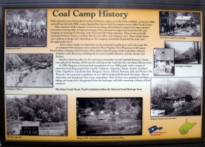
Coal Camp History
Mine operators built company-owned towns along railroad lines to support the huge numbers of workers arriving daily. A large percentage of the coal minerís wages was returned to the coal company in exchange for housing, tools, food and other basic expenses. These towns generally consisted of minersí homes, a school, church, post office, and company store. These simple homes were uniform in design and, depending on the company, sometimes all painted the same color throughout the town!
Life in these camps was dependent on the coal seamís production, and in the early 30ís an estimated 465 company towns existed in West Virginia. Over 90 percent of all miners lived in these company-owned camps. Here miners enjoyed many modern amenities unheard of before coalís discovery including electric power, public libraries, schools, doctors and dentists.
Another important place in the coal camp community was the baseball diamond. Games were played on Sunday, which was the only day in the week that the coal miners did not work.
In 1930, Kingston coal camp had a population of over 1200 people, with a variety of ethnicities including people from Canada, Lithuania, Argentina, Russia, Austria, Scotland, Cuba, Yugoslavia, Czechoslovakia, Hungary, Greece, Poland, Romania, Italy and Mexico. The Westerly coal camp had a population of over 660 including full-blooded Cherokees, African Americans and immigrants from many nationalities. Most of these once populated and flourishing coal camps have disappeared from the landscape with little remaining evidence of their existence.
The Paint Creek Scenic Trail is included within the National Coal Heritage Area.
Erected by Paint Creek Scenic Trail.
Topics. This historical marker is listed in these topic lists: Industry & Commerce • Settlements & Settlers. A significant historical year for this entry is 1930.
Location. 37° 58.533′ N, 81° 17.008′ W. Marker is in Mossy, West Virginia, in Fayette County. Marker is at the intersection of Bishop Ranch (West Virginia Route 612) and Milburn Road (County Route 1/5) when traveling east on Bishop Ranch. Touch for map. Marker is in this post office area: Scarbro WV 25917, United States of America. Touch for directions.
Other nearby markers. At least 8 other markers are within 7 miles of this marker, measured as the crow flies. Mossy (here, next to this marker); The Rebirth of Paint Creek (a few steps from this marker); Oakwood Mine Complex (approx. 5.1 miles away); William S. Dunbar (approx. 6.2 miles away); The White Oak Valley (approx. 6Ĺ miles away); Labor Strikes and Conflicts (approx. 6Ĺ miles away); Disaster Underground (approx. 6Ĺ miles away); The Coal Barons (approx. 6Ĺ miles away). Touch for a list and map of all markers in Mossy.
More about this marker. The period photos around the border of the panel include: “Kingston coal miners”, “Coal tipple at Milburn”, “Westerly coal camp”, “Kingston 1920 – Notice the cars, and the cow and man walking”, “Horse drawn wagons in a coal camp”, “Coal tipple at Kingston”, and
“Kingston company store and YMCA”.
Also see . . . Paint Creek Scenic Trails. (Submitted on August 15, 2010.)
Credits. This page was last revised on November 14, 2021. It was originally submitted on August 15, 2010, by Bernard Fisher of Richmond, Virginia. This page has been viewed 2,117 times since then and 118 times this year. Photos: 1, 2. submitted on August 15, 2010, by Bernard Fisher of Richmond, Virginia.

