Rye in Westchester County, New York — The American Northeast (Mid-Atlantic)
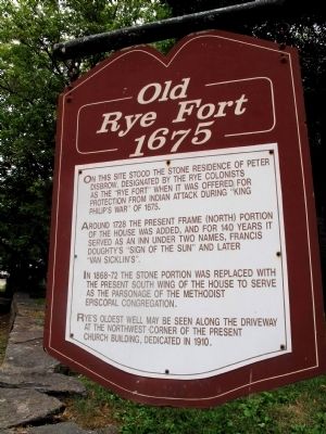
Old Rye Fort 1675
Around 1728 the present frame (North) portion of the House was added, and for 140 years it served as an inn under two names, Frances Doughty's "Sign of the Sun" and later "Van Sicklin's"
In 1868-72 the Stone portion was replaced with the present South wing of the house to serve as the parsonage of the Methodist Episcopal Congregation.
Rye's oldest well may be seen along the driveway at the Northwest corner of the present church building, dedicated in 1910."
Topics. This historical marker is listed in these topic lists: Colonial Era • Forts and Castles. A significant historical year for this entry is 1675.
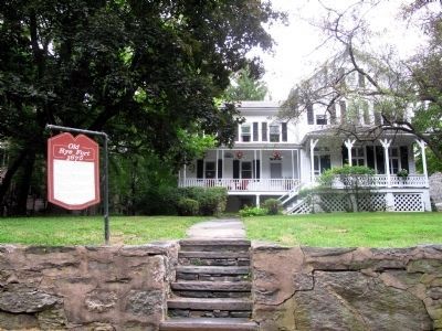
Location. 40° 58.652′ N, 73° 41.12′ W. Marker is in Rye, New York, in Westchester County. Marker is on Boston Post Road (U.S. 1 at milepost 25). Marker is located outside white building and to the left of the United Methodist Church structure which is made of stone. Touch for map. Marker is at or near this postal address: 964 Boston Post Road, Rye NY 10580, United States of America. Touch for directions.
Other nearby markers. At least 8 other markers are within 2 miles of this marker, measured as the crow flies. This is one of some 230 markers erected on the Boston Post Road in 1763 (approx. 0.2 miles away); The Purdy Burying Ground (approx. 0.8 miles away); Milton Cemetery (approx. 0.8 miles away); The Timothy Knapp House (approx. 0.9 miles away); African Cemetery 1860-1964 (approx. 0.9 miles away); Playland Amusement Park (approx. one mile away); The Bird Homestead and Rye Meeting House (approx. 1.3 miles away); Rye Meeting House (approx. 1.3 miles away). Touch for a list and map of all markers in Rye.
More about this marker. Two important historic sites located very close to this marker are:
1)The National Historic Landmark, Boston Post Road Historic District. This landmark includes the Jay Property, John Jay's boyhood home, which dates back to 1745 and is managed by the Jay Heritage Center, New York State Parks and Westchester County. Location: 210 Boston Post Road, Rye, NY.
2)A National Register Historic Place, The Square House (also known as Widow Haviland's Inn,) that dates back to 1730 and is the home of the Rye Historical Society. Location: 1 Purchase Street.
Regarding Old Rye Fort 1675. Peter Disbrow (1631-1688) was one of the original settlers and founders of Rye in 1660 along with Thomas Studwell and John Coe. The 3 men from Greenwich first purchased land on the Island of "Manussing" from the Siwanoy Indians before moving further inland after 1663. Rye is celebrating the legacy of all 3 men and the city's 350th anniversary this year in 2010.
Additional commentary.
1. I love this picture!!
Thank you, Thank you!! I was so happy when I came across this picture. I just couldn't believe it. This is my home.
Editor's note: Thank you for your kind words. All our marker pictures are submitted by interested volunteers. We are glad to have one from Rye now to capture this marker and others near your beautiful home.
— Submitted September 10, 2010, by Maria Elena Gutierrez of Rye, New York.
Credits. This page was last revised on June 16, 2016. It was originally submitted on August 16, 2010, by Suzanne Clary of Rye, New York. This page has been viewed 1,711 times since then and 58 times this year. Photos: 1, 2. submitted on August 16, 2010, by Suzanne Clary of Rye, New York. • Bill Pfingsten was the editor who published this page.

