Rye in Westchester County, New York — The American Northeast (Mid-Atlantic)
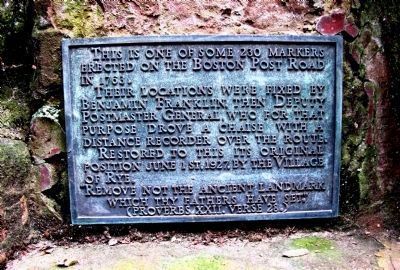
Boston Post Road
Their locations were fixed by Benjamin Franklin the Deputy Postmaster General who for that purpose drove a chaise with a distance recorder over the route. Restored to this its original position June 1st, 1927, by the Village of Rye.
'Remove not the ancient landmark which thy fathers have set.'(Proverbs XXII Verse 28.)
Erected 1927 by Village of Rye.
Topics. This historical marker is listed in these topic lists: Colonial Era • Patriots & Patriotism • Roads & Vehicles • War, US Revolutionary. A significant historical date for this entry is June 1, 1876.
Location. 40° 57.496′ N, 73° 42.33′ W. Marker is in Rye, New York, in Westchester County. Marker is on Boston Post Road (U.S. 1 at milepost 24). Touch for map. Marker is at or near this postal address: 210 Boston Post Road, Rye, NY 10580, Rye NY 10580, United States of America. Touch for directions.
Other nearby markers. At least 8 other markers are within 2 miles of this marker, measured as the crow flies. Boston Post Road Historic District (about 400 feet away, measured in a direct line); Milton Commercial District (approx. 0.9 miles away); Rye Meeting House (approx. 0.9 miles away); The Bird Homestead and Rye Meeting House (approx. 0.9 miles away); The Purdy Burying Ground (approx. 1.1 miles away); The Timothy Knapp House (approx. 1.1 miles away); Milton Cemetery (approx. 1.1 miles away); African Cemetery 1860-1964 (approx. 1.6 miles away). Touch for a list and map of all markers in Rye.
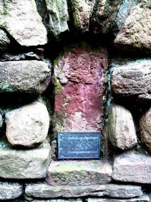
More about this marker. This rectangular metal marker was attached by the Village of Rye in 1927 to milestone or "marker" 24 of the Boston Post Road also known as the Kings Highway, one of America's oldest roads. Rye President John Morehead spearheaded the erection of these plaques as one of his "betterment" initiatives. The locations of the milestones were originally set by Benjamin Franklin (b.1706 - d.1790) in 1763 and some were replaced by the Westchester Turnpike Commission in the early 1800s. The spot Franklin marked was coincidentally located directly in front of John Jay's boyhood home in Rye, NY. Today 23 acres of Jay's 400 acre estate still lie intact behind the marker and are bounded in front by the length of a stone wall on Boston Post Road from the entrance at 210 all the way to Barlow Lane. This parcel known as the Jay Estate or Jay Property is the centerpiece of the National Historic Landmark Boston Post Road District NR82001275; it is a historic
site and park with 3 owners, the Jay Heritage Center, NY State, and Westchester County; it is open to the public for historical and educational programs.
Regarding Boston Post Road. John Jay would have been about 18 years old and Franklin about 57 when Franklin placed the first milestones that this marker commemorates! The milestones were not originally set into a wall - this wall was built in the early 1900s according to archival photos.
John Jay and Benjamin Franklin of course later became colleagues and are best remembered as 2 of America's Seven Founding Fathers. They are also known as the "Peace Commissioners" and along with John Adams, they negotiated the treaty that ended the Revolutionary War with Great Britain.
Credits. This page was last revised on August 6, 2020. It was originally submitted on August 14, 2010, by Suzanne Clary of Rye, New York. This page has been viewed 1,367 times since then and 52 times this year. Last updated on August 19, 2010, by Suzanne Clary of Rye, New York. Photos: 1, 2. submitted on August 14, 2010, by Suzanne Clary of Rye, New York. • Kevin W. was the editor who published this page.

