Near Garfield in Benton County, Arkansas — The American South (West South Central)
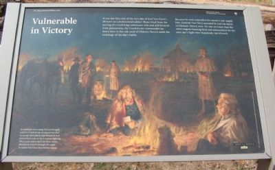
Vulnerable in Victory
March 7, 1862 - Mid-Night
— Pea Ridge National Military Park, National Park Service, U.S. Department of the Interior —
It was the fiery end of the best day of Earl Van Dorn's 20 years as a professional soldier. Bone-tired from the jarring of a week-long ambulance ride and still feverish from pneumonia, the Confederate commander lay down here in the side yard of Elkhorn Tavern amid the wreckage of the day's battle.
Because he now controlled his enemy's sole supply line, General Van Dorn assumed he had the battle of Elkhorn Tavern won. No one yet knew that the rebel wagons bearing food and ammunition for the next day's fight were hopelessly out of reach.
At midnight two young Texans brought word to Confederate headquarters that Generals McCulloch and McIntosh had been killed early in the Leetown fighting. They took orders back for their entire division to march through the night to rejoin Van Dorn here before sunup.
Erected by National Park Service, U.S. Department of the Interior.
Topics. This historical marker is listed in this topic list: War, US Civil.
Location. 36° 27.224′ N, 94° 0.93′ W. Marker is near Garfield, Arkansas, in Benton County. Marker can be reached from Military Park Road (County Road 65), on the left when traveling south. Located at stop eight, Elkhorn Tavern, on the driving tour of Pea Ridge National Military Park. Touch for map. Marker is in this post office area: Garfield AR 72732, United States of America. Touch for directions.
Other nearby markers. At least 8 other markers are within walking distance of this marker. Elkhorn Tavern Taken (within shouting distance of this marker); The Butterfield Overland Mail Route (within shouting distance of this marker); Lifeline for Two Armies (within shouting distance of this marker); Disastrous Retreat (within shouting distance of this marker); Pea Ridge and the Trail of Tears (within shouting distance of this marker); Remembrance and Reunion (about 400 feet away, measured in a direct line); A Reunited Soldiery Monument (about 500 feet away); Pea Ridge Confederate Monument (about 500 feet away). Touch for a list and map of all markers in Garfield.
Also see . . .
1. Pea Ridge National Military Park. National Park Service website entry (Submitted on September 12, 2010, by Craig Swain of Leesburg, Virginia.)
2. Pea Ridge (Elkhorn Tavern). American Battlefield Trust website entry (Submitted on May 8, 2021, by Larry Gertner of New York, New York.)

Photographed By Craig Swain, August 30, 2010
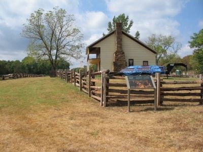
3. Elkhorn Tavern
The building is currently undergoing some repair and restoration. The tavern is not the original that stood at the site during the Civil War. The current structure is a fairly accurate reconstruction of the original, complete with elk skull and horns.
Credits. This page was last revised on June 19, 2023. It was originally submitted on September 12, 2010, by Craig Swain of Leesburg, Virginia. This page has been viewed 1,042 times since then and 12 times this year. Photos: 1, 2, 3. submitted on September 12, 2010, by Craig Swain of Leesburg, Virginia.

