Marblehead in Ottawa County, Ohio — The American Midwest (Great Lakes)
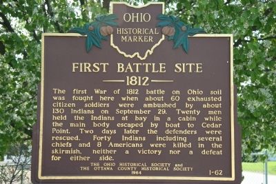
First Battle Site
1812
— Ohio Historical Marker —
Erected 1964 by The Ohio Historical Society and The Ottawa County Historical Society. (Marker Number 1-62.)
Topics and series. This historical marker is listed in these topic lists: Landmarks • Military • Native Americans • War of 1812. In addition, it is included in the Ohio Historical Society / The Ohio History Connection series list. A significant historical month for this entry is September 1865.
Location. 41° 30.862′ N, 82° 44.633′ W. Marker is in Marblehead, Ohio, in Ottawa County. Marker is on East Bay Shore Road just west of Seneca Trail, on the right when traveling east. This historical marker is located on the south side of the Marblehead peninsula, on the north side of the Sandusky Bay shores, and directly north of Johnson Island. Touch for map. Marker is in this post office area: Lakeside Marblehead OH 43440, United States of America. Touch for directions.
Other nearby markers. At least 8 other markers are within 2 miles of this marker, measured as the crow flies. In Memory of Mason, Simonds & Mingus (within shouting distance of this marker); The Keeper's House (about 500 feet away, measured in a direct line); Home of Benajah Walcott (about 500 feet away); a different marker also named The Keeper’s House (about 600 feet away); Johnson's Island (approx. half a mile away); Johnson's Island Civil War Prison and Fort Site (approx. 1.2 miles away); Johnson's Island Prison (approx. 1.2 miles away); Confederate Stockade Cemetery (approx. 1.2 miles away). Touch for a list and map of all markers in Marblehead.
More about this marker. There are several other related historical markers and memorials in the immediate area of this marker.
Related marker. Click here for another marker that is related to this marker. To better understand the relationship, study each marker in the order shown.
Credits. This page was last revised on June 16, 2016. It was originally submitted on May 14, 2009, by Dale K. Benington of Toledo, Ohio. This page has been viewed 2,588 times since then and 45 times this year. Last updated on September 20, 2010, by Jamie Abel of Westerville, Ohio. Photos: 1, 2. submitted on May 14, 2009, by Dale K. Benington of Toledo, Ohio. • Kevin W. was the editor who published this page.

