Near Spotsylvania Courthouse in Spotsylvania County, Virginia — The American South (Mid-Atlantic)
Jackson's Flank March
The Battle of Chancellorsville
— Fredericksburg and Spotsylvania National Military Park —
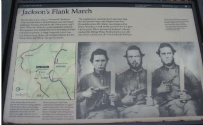
Shortly after 8 a.m., May 2, "Stonewall" Jackson's corps marched down the hill behind you and passed Catharine Furnace, bound for the Union Army's right flank. When the Federals spotted Jackson's column, they assumed the Confederates were retreating and sent a division in pursuit. A sharp rearguard action here cost Jackson most of the 23rd Georgia Infantry, but the Union efforts did little to disrupt his march.
The road Jackson used was much narrower than the one you see today, and progress was slow. By midafternoon, his column was strung out for nearly ten miles; it took nearly six hours for it to pass a given point. When the head of Jackson's column reached the Orange Plank Road around 3 p.m., the rear of the column was still near Catharine Furnace.
As his column passed this point, Jackson detached his leading regiment, Colonel Emory Best's 23rd Georgia, to guard this intersection. Best's men deployed in the woods one-half mile to your right, while the rest of Jackson's column continued on its way.
About noon, green-clad Union sharpshooters attacked the Georgians and drove them back. The Confederates made a brief stand here among the furnace buildings before falling back to the shelter of an unfinished railroad, one-half mile to your left. There, more than 250 of the Georgians surrendered.
Erected by National Park Service, U.S. Department of the Interior.
Topics. This historical marker is listed in this topic list: War, US Civil. A significant historical month for this entry is May 1718.
Location. 38° 17.338′ N, 77° 38.884′ W. Marker is near Spotsylvania Courthouse, Virginia, in Spotsylvania County. Marker is at the intersection of Jackson Trail East and Sickles Drive, on the right when traveling south on Jackson Trail East. Located at stop six of the driving tour of Chancellorsville Battlefield. Jackson Trail East is an unpaved road approximating the path of General Jackson's flank march on May 2, 1863. Touch for map. Marker is at or near this postal address: 11698 Jackson Trail E, Spotsylvania VA 22553, United States of America. Touch for directions.
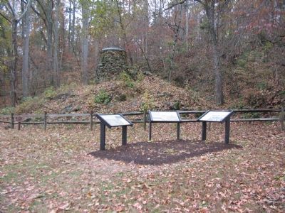
Other nearby markers. At least 8 other markers are within walking distance of this marker. Catharine Furnace (here, next to this marker); A Region of Gloom (a few steps from this marker); Chancellorsville Campaign (approx. 0.2 miles away); About a mile in the distance... (approx. half a mile away); Birthplace of Matthew Fontaine Maury (1806-1873) (approx. half a mile away); Maury Birthplace (approx. half a mile away); a different marker also named Chancellorsville Campaign (approx. 0.6 miles away); Maury House Trail (approx. 0.6 miles away). Touch for a list and map of all markers in Spotsylvania Courthouse.
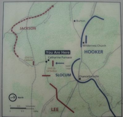
More about this marker. The right side of the marker displays a photograph of "Daniel, John, and Pleasant Chitwood" who "served as privates in the 23rd Georgia. Pleasant (right) died of disease in October 1862; Daniel and John were captured at Chancellorsville, exchanged, and fought for the remainder of the war." On the lower left is a map showing the battle events described in the marker text.
Regarding Jackson's Flank March. This is one of several markers for the Battle of Chancellorsville along McLaws Drive, Furnace Road, Sickles Drive, and East Jackson Trail, on the east side of the battlefield. See the McLaws's Line to Catharine Furnace Virtual Tour by Markers in the links section for a listing of related markers on the tour.
Also see . . .
1. Battle of Chancellorsville. National Parks Service site. (Submitted on November 17, 2007, by Craig Swain of Leesburg, Virginia.)
2. Heat at Catherine Furnace. On May 1, Jackson rode out to Catharine Furnace to gather information about Federal dispositions. There he came under fire from Federal artillery. The incident is the subject of a John Paul Strain painting. (Submitted on November 17, 2007, by Craig Swain of Leesburg, Virginia.)
3. McLaws's Line to Catharine Furnace Virtual Tour by Markers. Spread across a two mile segment on the east side of the battlefield, this virtual tour
by markers covers action from May 1-3, 1863. (Submitted on November 17, 2007, by Craig Swain of Leesburg, Virginia.)
Credits. This page was last revised on April 25, 2023. It was originally submitted on November 17, 2007, by Craig Swain of Leesburg, Virginia. This page has been viewed 1,595 times since then and 12 times this year. Photos: 1, 2, 3. submitted on November 17, 2007, by Craig Swain of Leesburg, Virginia. 4. submitted on April 24, 2023, by Bill Coughlin of Woodland Park, New Jersey.


