Near Fredericksburg in Spotsylvania County, Virginia — The American South (Mid-Atlantic)
Chancellorsville Campaign
Lee’s Greatest Victory
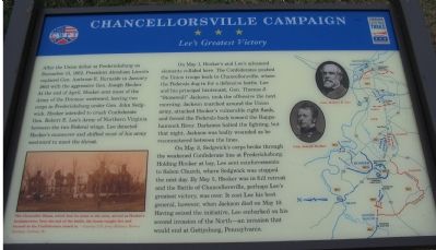
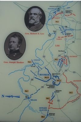
On May 1, Hooker's and Lee's advanced elements collided here. The Confederates pushed the Union troops back to Chancellorsville, where the Federals dug in for a defensive battle. Lee and his principle Lieutenant, Gen. Thomas J. "Stonewall" Jackson, took the offensive the next morning. Jackson marched around the Union army, attacked Hooker's vulnerable right flank, and forced the Federals back toward the Rappahannock River. Darkness halted the fighting, but that night, Jackson was badly wounded as he reconnoitered between the lines.
On May 3, Sedgwick's corps broke through the weakened Confederate line at Fredericksburg. Holding Hooker at bay, Lee sent reinforcements to Salem Church, where Sedgwick was stopped the next day. By May 5, Hooker was in full retreat and the Battle of Chancellorsville, perhaps Lee's greatest victory, was over. It cost Lee his best general, however, when Jackson died on May 10. Having seized the initiative, Lee embarked on his second invasion of the North - an invasion that would end at Gettysburg, Pennsylvania.
Erected by Virginia Civil War Trails.
Topics and series. This historical marker is listed in this topic list: War, US Civil. In addition, it is included in the Virginia Civil War Trails series list. A significant historical month for this entry is January 1863.
Location. This marker has been replaced by another marker nearby. 38° 17.77′ N, 77° 35.786′ W. Marker is near Fredericksburg, Virginia, in Spotsylvania County. Marker is on Plank Road (State Highway 3), on the right when traveling east. This marker has been replaced by another marker at the same spot. It was located at the parking area for on a 140 acres tract preserved by Central Virginia Battlefields Trust. Touch for map. Marker is at or near this postal address: 6161 Plank Road, Fredericksburg VA 22407, United States of America. Touch for directions.
Other nearby markers. At least 8 other markers are within walking distance of this location. A different marker also named Chancellorsville Campaign (here, next to this marker); The First Day at Chancellorsville (here, next to this marker); a different marker also named First Day at Chancellorsville (here, next to this marker); a different marker also named First Day at Chancellorsville (approx. 0.2 miles away); a different marker also named First Day at Chancellorsville (approx. 0.2 miles away); a different marker also named First Day at Chancellorsville (approx. 0.2 miles away); a different marker also named First Day at Chancellorsville (approx. 0.3 miles away); a different marker also named First Day at Chancellorsville (approx. 0.3 miles away). Touch for a list and map of all markers in Fredericksburg.
More about this marker. On the lower left is a photo of "The Chancellor House, which lent its name to the area" and "served as Hooker's headquarters. Near the end of the battle, the house caught fire and burned as the Confederates closed in." The right side displays a campaign map of the battle with portraits of Gens. Robert E. Lee and Joseph Hooker.
Regarding Chancellorsville Campaign. Additional kiosks and markers nearby detail preservation efforts by local and national organizations which ensured this section of the battlefield, which was not originally included within the National Park Service
Photographed By Craig Swain, November 10, 2007
3. Kiosks and Markers at the First Day Battlefield
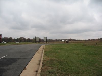
This marker is on the far right. The Civil War Preservation Trust placed two kiosks on site. The left most details those who aided preservation efforts for this site. The kiosk on the right explains the preservation efforts to date.
This marker is grouped with the markers along McLaws Drive, Furnace Road, Sickles Drive, and East Jackson Trail, on the east side of the battlefield. See the McLaws's Line to Catharine Furnace Virtual Tour by Markers in the links section for a listing of related markers on the tour.
Also see . . . Civil War Preservation Trust. More information about the CWPT and efforts to preserve Civil War sites around the country. (Submitted on November 18, 2007, by Craig Swain of Leesburg, Virginia.)
Photographed By Craig Swain, November 10, 2007
4. Civil War Preservation Trust
Saving America's Hallowed Ground
Saving America's Hallowed Ground
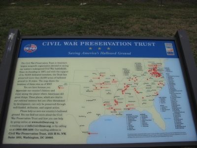
The Civil War Preservation Trust is America's largest nonprofit organization devoted to saving our nation's endangered Civil War battlefields. Since its founding in 1987, and with the support of its 70,000 dedicated members, the Trust has preserved more than 24,000 acres of hallowed ground in 18 states. The map shows the locations of these sites as of 2007.
You are here because you appreciate our country's history and enjoy seeing the places where Americans did great things. These places, which are vital to our national memory but are often threatened by development, can only be preserved through well-funded, deliberate, and urgent action.
Please help us save our country's hallowed ground. You can find out more about the Civil War Preservation Trust and how you can help by going online at www.civilwar.org, by e-mailing us at [email protected], or by calling us at (888) 606-1400. Our mailing address is Civil War Preservation Trust, 1331 H. St. NW, Suite 1001, Washington, DC 20005.
Photographed By Craig Swain, November 10, 2007
5. First Day at Chancellorsville
Developer's Plan Runs into a "Stonewall"
Developer's Plan Runs into a "Stonewall"
Included as a history of the marking and preserving of historical sites note of interest.
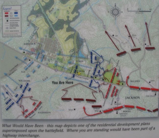
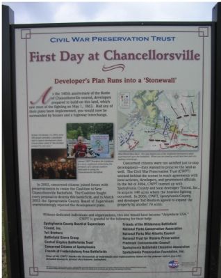
As the 140th anniversary of the Battle of Chancellorsville neared, developers prepared to build on this land, which saw most of the fighting on May 1, 1863. Had any of their plans been implemented, you would now be surrounded by houses and a highway interchange.
In 2002, concerned citizens joined forces with preservationists to create the Coalition to Save Chancellorsville Battlefield. The Coalition fought every proposal to destroy this battlefield, and in March 2003 the Spotsylvania County Board of Supervisors overwhelmingly rejected the development plans.
Concerned citizens were not satisfied just to stop development - they wanted to preserve the land as well. The Civil War Preservation Trust (CWPT) worked behind the scenes to reach agreements with local activists, developers, and government officials. In the fall of 2004, CWPT teamed up with Spotsylvania County and local developer Tricord, Inc., to acquire 140 acres where the heaviest fighting occurred. In 2006, CWPT, Spotsylvania County, and developer Toll Brothers agreed to expand the property by another 74 acres.
Credits. This page was last revised on February 2, 2023. It was originally submitted on November 18, 2007, by Craig Swain of Leesburg, Virginia. This page has been viewed 1,532 times since then and 18 times this year. Last updated on September 10, 2021, by Bradley Owen of Morgantown, West Virginia. Photos: 1, 2, 3, 4, 5, 6. submitted on November 18, 2007, by Craig Swain of Leesburg, Virginia. • J. Makali Bruton was the editor who published this page.
