Near Stafford in Stafford County, Virginia — The American South (Mid-Atlantic)
Aquia Landing
Supply Base for the Union Army
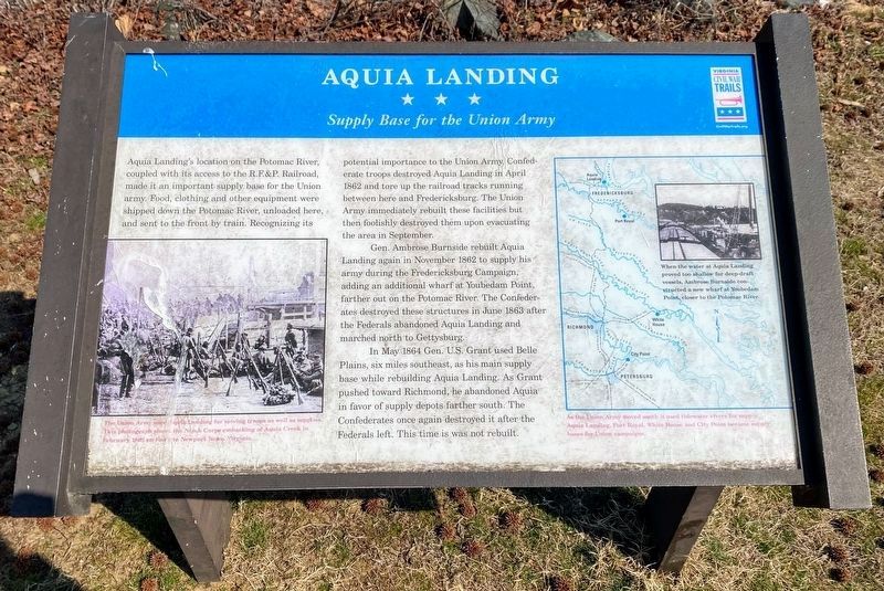
Gen. Ambrose Burnside rebuilt Aquia Landing again in November 1862 to supply his army during the Fredericksburg Campaign, adding an additional wharf at Youbedam Point, farther out on the Potomac River. The Confederates destroyed these structures in June 1863 after the Federals abandoned Aquia Landing and marched north to Gettysburg.
In May 1864 Gen. U.S. Grant used Belle Plains, six miles southeast, as his main supply base while rebuilding Aquia Landing. As Grant pushed toward Richmond, he abandoned Aquia in favor of supply depots farther south. The Confederates once again destroyed it after the Federals left. This time it was not rebuilt.
(caption, lower left photograph): The Union Army used Aquia Landing for moving troops as well as supplies. This photograph shows the Ninth Corps embarking at Aquia Creek in February 1863 en route to Newport News, Virginia.
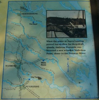
(caption, map on right): As the Union Army moved south it used tidewater rivers for supply. Aquia Landing, Port Royal, White House and City Point became supply bases for Union campaigns.
(caption, photograph in map): When the water at Aquia Landing proved too shallow for deep-draft vessels, Ambrose Burnside constructed a new wharf at Youbedam Point, closer to the Potomac River.
Erected by Virginia Civil War Trails.
Topics and series. This historical marker is listed in these topic lists: Military • War, US Civil • Waterways & Vessels. In addition, it is included in the Former U.S. Presidents: #18 Ulysses S. Grant, and the Virginia Civil War Trails series lists. A significant historical month for this entry is February 1863.
Location. 38° 23.382′ N, 77° 18.966′ W. Marker is near Stafford, Virginia, in Stafford County. Marker is on Brooke Road (County Route 608), on the right when traveling north. Marker is in Aquia Landing County Park (formerly Aquia-Po Beach Park). Touch for map. Marker is at or near this postal address: 2846 Brooke Rd, Stafford VA 22554, United States of America. Touch for directions.
Other nearby markers. At least 8 other markers are within walking distance of this marker. A different marker also named Aquia Landing (within shouting distance of this marker); Steamships, Stages and Slave Trade (within shouting distance of this marker); Early Escape Route (within shouting distance of this marker); Gateway to Freedom (within shouting distance of this marker); Patawomeck Tribe Village (approx. ¼ mile away); a different marker also named Aquia Landing (approx. half a mile away); History of the Patawomeck Indians (approx. half a mile away); a different marker also named Aquia Landing (approx. 0.6 miles away). Touch for a list and map of all markers in Stafford.
Credits. This page was last revised on May 26, 2022. It was originally submitted on November 19, 2007, by Kevin W. of Stafford, Virginia. This page has been viewed 3,460 times since then and 78 times this year. Photos: 1. submitted on May 23, 2022, by Shane Oliver of Richmond, Virginia. 2, 3. submitted on November 19, 2007, by Kevin W. of Stafford, Virginia. 4, 5. submitted on January 19, 2008. 6. submitted on May 23, 2022, by Shane Oliver of Richmond, Virginia.
