Sandston in Henrico County, Virginia — The American South (Mid-Atlantic)
Battle of Savage’s Station
A Fighting Withdrawal
— 1862 Peninsula Campaign —
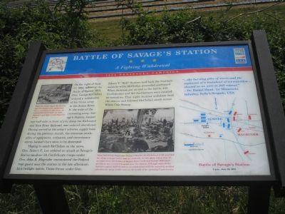
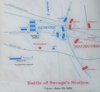
Hoping to catch McClellan on the move, Gen. Robert E. Lee ordered an attack at Savage’s Station on June 29, Confederate troops under Gen. John Magruder encountered the Federal rear guard near the station in the late afternoon. In a twilight battle, Union forces under Gen. Edwin V. “Bull” Sumner held back the Southern assaults while McClellan proceeded southward. When darkness put an end to the battle, 444 Confederates and 919 Northerners were counted as casualties. That night, Sumner withdrew from the station and followed McClellan south across White Oak Swamp.
“…the burning piles of stores and the explosion of a trainload of ammunition…showed us we were in full retreat.”
- Dr. Daniel Hand, 1st Minnesota Infantry, Sully’s Brigade, USA
Erected by Virginia Civil War Trails.
Topics and series. This historical marker is listed in this topic list: War, US Civil. In addition, it is included in the Virginia Civil War Trails series list. A significant historical date for this entry is June 7, 1862.
Location. 37° 31.693′ N, 77° 16.132′ W. Marker is in Sandston, Virginia, in Henrico County. Marker is on Meadow Road (County Route 156), on the right when traveling east. Touch for map. Marker is in this post office area: Sandston VA 23150, United States of America. Touch for directions.
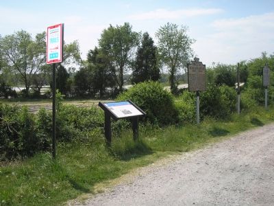
Other nearby markers. At least 8 other markers are within 2 miles of this marker, measured as the crow flies. Battle For The Rails (here, next to this marker); a different marker also named Battle of Savage's Station (a few steps from this marker); Route to White Oak Swamp and Malvern Hill (a few steps from this marker); Savage Station (a few steps from this marker); The Trent House (approx. 1.2 miles away); Seven Days Battles (approx. 1.3 miles away); a different marker also named Battle of Savage's Station (approx. 1.4 miles away); a different marker also named The Trent House (approx. 1.4 miles away). Touch for a list and map of all markers in Sandston.
More about this marker. A drawing on the upper left carries the caption: While the battle raged, the destruction of ordnance and commissary stores continued. In this scene,
an ammunition train blows up while Sumner’s men fight to hold Magruder at bay.
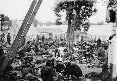
A photo in the lower center is captioned: When McClellan abandoned Savage’s Station, he left behind 2,500 wounded for whom transportation was not available. In this photo taken June 28, wounded from the battles of Beaver Dam Creek and Gaines’ Mill await treatment at a crowded hospital near the station. Although some of the Federal surgical staff elected to remain behind with the wounded, medical attention for many would come at the hands of the pursuing Confederates.
On the right side a map details the tactical situation discussed in the text.

Photographed By James F. Gibson, 1862
4. Savage Station, Virginia. Union field hospital after the battle of June 27
Photo shows a makeshift field hospital with wounded soldiers sitting and lying on the ground while some receive care. Includes the straw-hatted Sixteenth New York Infantry who fought at Gaines' Mill on June 27. Most were captured when Confederates overtook the area during the battle of Savage's Station on June 29. (Source: Bob Zeller, Civil War in Depth, v. 1, p. 34) - Library of Congress. This is the same photograph as on the marker, but without cropping.
Credits. This page was last revised on April 28, 2022. It was originally submitted on November 19, 2007, by Bill Coughlin of Woodland Park, New Jersey. This page has been viewed 4,669 times since then and 111 times this year. Photos: 1, 2. submitted on November 19, 2007, by Bill Coughlin of Woodland Park, New Jersey. 3. submitted on November 20, 2007, by Bill Coughlin of Woodland Park, New Jersey. 4. submitted on September 30, 2015. • Craig Swain was the editor who published this page.


