Keauhou in Hawaii County, Hawaii — Hawaiian Island Archipelago (Pacific Ocean)
Hale Mua
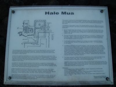
Evidence that supports the identification as a men's house is the architectural construction of this site, which is similar to other known men's houses elsewhere in the Hawaiian Islands. The presence of pig bone at the site is significant as pig was a food prohibited to women. Of the large quantity of artifacts found at this site, none were associated with women. Male ornaments found at this site are suggestive of rank or status.
Occupants who lived at this site were retainers of the chief who occupied the Lonoikamakahiki Residence site. Among the retainers who lived at this site was the chief's steward who prepared all of the chief's meals, manufacturing of fishing gear and other items.
Artifacts recovered from this site included cowry lures for octopus fishing, trolling lures, fishing weights, unfinished bone fish hooks, nerita shell beads for necklaces or bracelets, dog-tooth ornaments for use as a pendant or part of an anklet, adzes, abraders, miscellaneous bird, fish and animal bones, charcoal, sea urchin parts, sea shells, candle nuts (kukui) for lighting, etc.
These men's houses were called a mua. The mua was strictly forbidden to women. As soon as a male child was weaned and began to partake of other food, he was taken to the mua and was no longer allowed to take food in the company of women. These muas served as places of both secular and ritual activities pertaining only to the male sex.
This structure, as well as the Lonoikamakahiki Residence, was constructed with a high thatched roof. All that remains is the stone foundation. This site may have had a thatched enclosure over each of the different features except for the goat pen and the fireplace where the alii's food was cooked.
References:
Archaeological Survey, Kahaluu, North Kona, Hawaii; Department of Anthropology, Bernice P. Bishop Museum. Report 71-4.
Archaeological Excavations at Kahaluu, North Kona, Island of Hawaii; Department of Anthropology, Bernice P. Bishop Museum. Report 73-1.
Henry P. Kekahuna. Map of Kahaluu Beach; site and place names, legends and history. March 15, 1952.
Researched and Written by Joseph N. Castelli, 1988.
Topics. This historical marker is listed in these topic lists: Anthropology & Archaeology • Native Americans. A significant historical date for this entry is March 15, 1812.
Location. 19°
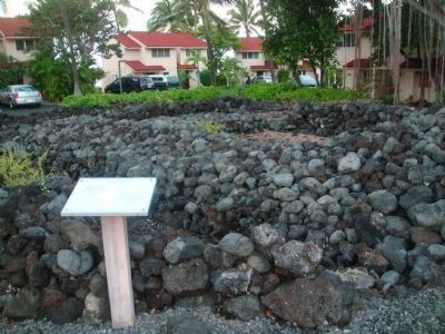
34.398′ N, 155° 58.039′ W. Marker is in Keauhou, Hawaii, in Hawaii County. Marker can be reached from Alii Drive, half a mile north of Kamehameha III Road, on the left when traveling north. The marker is on the grounds of the Keauhou Kona Surf and Racquet Club, which is a gated community. The Club must allow public shoreline access and, therefore, the marker is presumably accessible to the public. Park on the road near the gate. The marker is just inside the gate next to the pool. Touch for map. Marker is at or near this postal address: 78-6800 Alii Drive, Keauhou HI 96739, United States of America. Touch for directions.
Other nearby markers. At least 8 other markers are within walking distance of this marker. Lonoikamakahiki Residence (within shouting distance of this marker); Inikiwai Ku'ula Heiau (approx. 0.2 miles away); Keauhou - Kahalu'u Heritage Corridor (approx. 0.4 miles away); Kuemanu Heiau (approx. 0.6 miles away); Kauikeaouli, Kamehameha III (approx. 0.9 miles away); Keauhou Bay (approx. 0.9 miles away); Birthplace of Kauikeaouli (approx. 0.9 miles away); Kauikeaouli and Nāhi'ena'ena (approx. 0.9 miles away). Touch for a list and map of all markers in Keauhou.
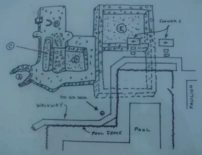
More about this marker. The following is a description of each of the separate features of this site. Refer to the isometric layout drawing of this site. Each feature has been given an alphabetical designation for ease of identification.
A. Sacred Fireplace (Kapu Ahi) of Royalty. Food for the king and other alii was cooked in this fireplace. Today the hearth of this fireplace contains an abundance of carbon from ancient fireplace fuels. Mixed with carbon are fragments of shellfish and animal bones that were cooked for the alii.
B. This is the foundation of the house of the Chief Steward ('a'i-pu'upu'u). It measures 18 feet by 22 feet. There is a step on the west side. This is where the doorway to the Steward's house was located. A stone-lined hearth was just inside the door and is probably where the Chief Steward prepared his own food.
C. This elongated enclosure is believed to be a storage area were sacred food destined for the alii was kept. Hydration-Rind age determination of 1576 + - 21 AD was obtained for this feature.
D. This feature is believed to be a house enclosure. It may have been used for a sleeping area as well as for religious rituals. It is believed that it may have also served as an area where the meals for the alii were prepared. This feature is almost in the shape of a square, measuring 30 feet by 33 feet including the wall peripheral on the north, east and south side as well as the waterworn cobbled double level platform on the west side. This two level platform was the base of a thatched house added during the period of 1575 to 1600 AD. The center pit measures 16 feet
by 15 feet. The floor of this pit is paved with small a'a lava stones as well as ili'ili pebbles (small waterworn stones). Hydration-Rind age measurement indicates this feature was started 1550 AD.
E. This feature was built in historic times as a goat pen by Lu'-kia, a lesser chief after the time of Governor Kuakini (after 1844). It was built as a double pen but one section was destroyed during construction of the Surf and Racquet Club.
Adjacent to, and just west of the goat pen where Unit 48 and part of the present pavilion now stands, was a men's eating house for close relatives of the chief. It is believed thta rocks were robbed from its foundation to construct the goat pen. What was left was destroyed during construction of the Surf and Racquet Club.
Credits. This page was last revised on June 16, 2016. It was originally submitted on January 2, 2011, by William J. Toman of Green Lake, Wisconsin. This page has been viewed 1,239 times since then and 44 times this year. Photos: 1, 2, 3, 4. submitted on January 2, 2011, by William J. Toman of Green Lake, Wisconsin. • Syd Whittle was the editor who published this page.


