Near Church Creek in Dorchester County, Maryland — The American Northeast (Mid-Atlantic)
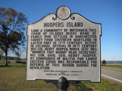
Hoopers Island
Erected by Maryland Bicentennial Commission, Maryland Historical Society.
Topics. This historical marker is listed in these topic lists: Colonial Era • Patriots & Patriotism • Settlements & Settlers • War, US Revolutionary.
Location. 38° 20.84′ N, 76° 13.633′ W. Marker is near Church Creek, Maryland, in Dorchester County. Marker is on Hoopers Island Road (Maryland Route 335) 3 miles south of Meekins Neck Road, on the right when traveling south. Marker is about 400 feet south of Fishing Creek bridge. Touch for map. Marker is at or near this postal address: 2837 Hoopers Island Rd, Fishing Creek MD 21634, United States of America. Touch for directions.
Other nearby markers. At least 8 other markers are within 9 miles of this marker, measured as the crow flies. St. Mary, Star of the Sea Chapel & Cemetery (approx. 2.9 miles away); Highway to Freedom (approx. 8˝ miles away); Harriet Tubman Underground Railroad Visitor Ctr. (approx. 8˝ miles away); The Underground Railroad (approx. 8˝ miles away); Harriet Tubman (approx. 8˝ miles away); The Harriet Tubman Underground Railroad Byway (approx. 8˝ miles away); The Harriet Tubman Underground Railroad Visitor Center (approx. 8˝ miles away); Blackwater National Wildlife Refuge (approx. 8.6 miles away). Touch for a list and map of all markers in Church Creek.
Credits. This page was last revised on August 31, 2022. It was originally submitted on December 5, 2007, by F. Robby of Baltimore, Maryland. This page has been viewed 3,219 times since then and 49 times this year. Photo 1. submitted on December 5, 2007, by F. Robby of Baltimore, Maryland.
