Near Lyndon Station in Juneau County, Wisconsin — The American Midwest (Great Lakes)
The Wisconsin River
“The Nation’s Hardest-Working River”
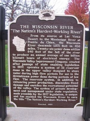
From its source at Lac Vieux Desert to the Mississippi River at Prairie du Chien, the Wisconsin River descends 1,071 feet in 430 miles. Twenty-six power dams utilize 640 feet of the fall of the river to produce an annual average of one billion kilowatt hours of electrical energy. The Wisconsin Valley Improvement Company, created after passage of state enabling legislation in 1907, operates a system of 21 reservoir dams in the upper valley designed to store water during high flow periods for use in the downstream power dams during periods of low flow. The reservoir system, in addition to enhancing power production, diminishes flood damage and enriches the recreational potential of the valley. The system of private development and management under state regulation, made possible by the 1907 legislation, is unique and has enabled the Wisconsin River to earn the title "The Nation's Hardest-Working River."
Erected 1982 by the Wisconsin Historical Society. (Marker Number 269.)
Topics and series. This historical marker is listed in this topic list: Waterways & Vessels. In addition, it is included in the Wisconsin Historical Society series list. A significant historical year for this entry is 1907.
Location. 43° 45.45′ N, 89° 58.05′ W. Marker is near Lyndon Station, Wisconsin, in Juneau County. Marker can be reached from Interstate 90/94 at milepost 74, on the right when traveling east. Marker is northwest of Lyndon Station at eastbound Rest Area 9. Touch for map. Marker is in this post office area: Lyndon Station WI 53944, United States of America. Touch for directions.
Other nearby markers. At least 8 other markers are within 10 miles of this marker, measured as the crow flies. The Iron Brigade (within shouting distance of this marker); The Sand Counties – Aldo Leopold Territory (approx. one mile away); Wisconsin Veterans Memorial Highway (approx. one mile away); Lyndon Station Area Veterans Memorial (approx. 4.6 miles away); Hop Raising (approx. 4.8 miles away); Orland S. Loomis (1893–1942) (approx. 6 miles away); Stewart's Chapel (approx. 6.6 miles away); Leaping the Chasm (approx. 9.4 miles away). Touch for a list and map of all markers in Lyndon Station.
Regarding The Wisconsin River. The Wisconsin Valley Improvement Company is unique because no other company coordinates an entire river system from one central location for several separate waterpower users.
Also see . . .
1. Wisconsin River. Wikipedia entry (Submitted on January 7, 2022, by Larry Gertner of New York, New York.)
2. Wisconsin Valley Improvement Company. Wikipedia entry (Submitted on January 7, 2022, by Larry Gertner of New York, New York.)
Credits. This page was last revised on January 7, 2022. It was originally submitted on December 11, 2007, by Keith L of Wisconsin Rapids, Wisconsin. This page has been viewed 1,923 times since then and 42 times this year. Photos: 1, 2. submitted on December 11, 2007, by Keith L of Wisconsin Rapids, Wisconsin. • J. J. Prats was the editor who published this page.

