Strip District in Pittsburgh in Allegheny County, Pennsylvania — The American Northeast (Mid-Atlantic)
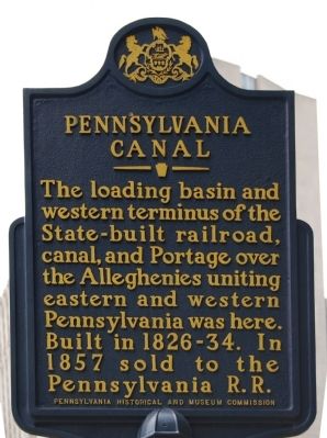
Pennsylvania Canal
Erected 1958 by Pennsylvania Historical and Museum Commission.
Topics and series. This historical marker is listed in these topic lists: Railroads & Streetcars • Waterways & Vessels. In addition, it is included in the Pennsylvania Canal, and the Pennsylvania Historical and Museum Commission series lists. A significant historical year for this entry is 1857.
Location. 40° 26.647′ N, 79° 59.592′ W. Marker is in Pittsburgh, Pennsylvania, in Allegheny County. It is in the Strip District. Marker is on Liberty Avenue, 0.1 miles east of 11th Street, on the right when traveling east. Touch for map. Marker is in this post office area: Pittsburgh PA 15222, United States of America. Touch for directions.
Other nearby markers. At least 8 other markers are within walking distance of this marker. The Empty Pocket Pays (within shouting distance of this marker); "The Bell Speaks" (about 700 feet away, measured in a direct line); Gulf Building (approx. 0.2 miles away); Refining Crude Oil (approx. 0.2 miles away); Kier Refinery (approx. 0.2 miles away); Lewis and Clark Expedition (approx. ¼ mile away); Fort Lafayette (approx. ¼ mile away); Founding Convention of the AFL (approx. 0.3 miles away). Touch for a list and map of all markers in Pittsburgh.
Also see . . .
1. Pennsylvania Canal Society. (Submitted on May 6, 2011, by Mike Wintermantel of Pittsburgh, Pennsylvania.)
2. Pennsylvania Canal - Behind the Marker. (Submitted on June 29, 2011, by Mike Wintermantel of Pittsburgh, Pennsylvania.)

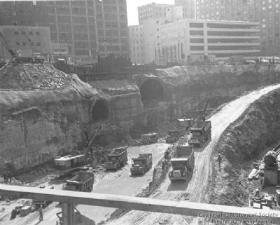
Photographed By Richard B. Patton, 1968
3. Pennsylvania Canal Tunnel
The opening for the Pennsylvania Canal Tunnel is on the left of the photo. The opening on the right is a Pennsylvania Railroad Tunnel. The site is currently occupied by the USX Tower.
Courtesy: Western Pennsylvania Historical Society
Credits. This page was last revised on February 2, 2023. It was originally submitted on May 6, 2011, by Mike Wintermantel of Pittsburgh, Pennsylvania. This page has been viewed 1,023 times since then and 43 times this year. Photos: 1, 2, 3. submitted on May 6, 2011, by Mike Wintermantel of Pittsburgh, Pennsylvania. • Bill Pfingsten was the editor who published this page.

