Paterson in Passaic County, New Jersey — The American Northeast (Mid-Atlantic)
The Allied Textile Printing Site
The Allied Textile Printing (ATP) Site is a 7.5 acre portion of the Great Falls of Paterson/S.U.M. Historic District. Toward the end of the eighteenth century, the newly established United States sought to increase its economic as well as political independence from Europe. In 1791, Alexander Hamilton and other men of influence chartered a company, the Society for Establishing Useful Manufactures (S.U.M.), for that purpose. Their strategy included harnessing the natural power of the Great Falls for the production of manufactured goods. In so doing, the S.U.M. created the nationís first planned industrial development on the banks of the Passaic River.
On April 1, 2009 President Obama signed into law the Paterson Great Falls National Historical Park Act. This new unit of the National Park Service will be managed by a partnership between the National Park Service and the New Jersey Department of Environmental Protection in collaboration with the City of Paterson and other local interests. The Great Falls National Park designation, along with a long-term plan for restoration and development in the surrounding neighborhoods, helps set the stage for private investment that can help revitalize Paterson.
[ Sidebar: ]
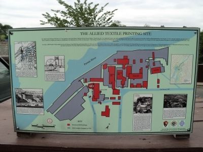
Several pictures appear on the marker. The captions are as follows:
From above the Great Falls of the Passaic River, a canal and a series of raceways (highlighted in blue) carried water to the mills below the falls. Although initially a simple and direct system, new segments were added as additional mills were built, and eventually the complex of waterways surpassed all previous attempts to harness the power of nature for use in industry.
The terrace at the south end of the site was the first location that permitted the return of water back to the river. This is thought to be the site of the early sawmill and the millerís house. Both of these buildings were small by todayís standards, with an approximately 20 feet-square sawmill and a 2½ story millerís house made of square-cut logs. These buildings were connected to each other and the rest of the complex by a rough road of stone and logs.
The mid-eighteenth century also saw the establishment of the Todd & Raftery's Machine Company on the Passaic riverbank. The larger machine works, later referred to as Todd Mill included a foundry, blacksmith shops, and various support buildings. The Todd Machine Shop supplied textile making machinery, steam engines and all types of manufacturing machinery to Pattersonís mills as well as factories across America and across the world. The business closed down in the mid-1890ís.
The Colt Gun Mill was built in 1836 by Samuel Coltís company, the Patent Arms Manufacturing Company, to make the famous revolving firearms that Colt had newly invented. The five story stone mill was large enough to manufacture colt revolvers and provide space to Samuelís brother, Christopher Colt, who became the first man in Paterson to make silk. Guns ceased production in 1842, but cotton and silk makers moved into the large space. John Ryle, father of Patersonís silk industry, was one of these early occupants of the former Gun Mill. The success of silk manufacturing and dyeing spawned many new firms and spread throughout the city, including the neighboring, Waverly and Mallory Mills. By 1880 nearly one-third of American silk workers were employed in Paterson. The majority of these laborers were immigrants and a large proportion was women.
Silk weaving and the dyeing and finishing of fabric were the primary industries in Paterson during the 20th century. In 1938 Allied Textile Printers, Inc. was formed through the merger of several small to mid-sized textile interests in Paterson. The Standard Dyeing & Finishing Company was established in the 1960ís from ATP assets, and occupied the large dye houses at the south of the complex. Financial problems forced the termination of all operations in 1982. Fire, time, and the elements have reduced the once thriving industrial complex to its current state.
Topics. This historical marker is listed in this topic list: Industry & Commerce. A significant historical month for this entry is April 1880.
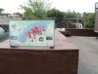
Location. 40° 54.925′ N, 74° 10.8′ W. Marker is in Paterson, New Jersey, in Passaic County. Marker is at the intersection of McBride Avenue and Spruce Street, on the left when traveling east on McBride Avenue. Marker is located in Haines Overlook Park. Touch for map. Marker is in this post office area: Paterson NJ 07501, United States of America. Touch for directions.
Other nearby markers. At least 8 other markers are within walking distance of this marker. The 1914 S.U.M. Great Falls Power Plant (within shouting distance of this marker); Harry B. Haines Memorial Park (within shouting distance of this marker); Great Falls of the Passaic/S.U.M. Historic District (within shouting distance of this marker); Great Falls of Paterson on the Passaic (within shouting distance of this marker); Overlook Park (within shouting distance of this marker); Captain Eric M. Graupe (within shouting distance of this marker); Passaic Falls (within shouting distance of this marker); Great Falls Hydroelectric Station (about 300 feet away, measured in a direct line). Touch for a list and map of all markers in Paterson.
More about this marker. The background of the marker contains a map of the complex showing the Historical Mill Buildings and the Mill Complex Footprint in 1983. The site of the marker is shown on the map, as well as the Passaic River; Middle and Lower Raceways; Colt Gun Mill; Mallory Mill; Waverly Mill; Passaic Mill and Todd Mill.
Credits. This page was last revised on June 16, 2016. It was originally submitted on June 6, 2011, by Bill Coughlin of Woodland Park, New Jersey. This page has been viewed 830 times since then and 36 times this year. Photos: 1, 2, 3, 4. submitted on June 6, 2011, by Bill Coughlin of Woodland Park, New Jersey.


