Cherokee in Swain County, North Carolina — The American South (South Atlantic)
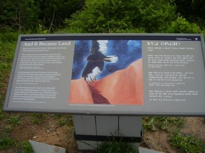
And It Became Land
How did this land come to be?
They carefully got all the mud and they laid it out on the rocks. And when it was dry enough, Grandfather threw it out into the water, and it became land. And the buzzard flew with his great wings. Each time when his wings went down, it would make a big valley, and each time the wings would go up,it would make a big mountain.
Adapted from Living Stories of the Cherokee, “How the World Was Made,” Kathi Smith Littlejohn
In the beginning God created the heaven and the earth....And God said, Let the waters under the heaven be gathered together unto one place, and let the dry land appear: and it was so. And God called the dry land Earth; and the gathering together of the waters he called seas.
Genesis I:I,9,10, The Bible, King James Version
The earliest beginnings of the Great Smoky Mountains were a time of drastic fluctuations of temperature and massive upheavals in the earth's crust. The bedrock of the Appalachian chain was probably [millions of] years old when it was metamorphosed and partially melted in the first mountain-building phase.
Great Smoky Mountains: The Story Behind the Scenery, Rita Cantu
Erected by National Park Service, Department of the Interior.
Topics. This historical marker is listed in this topic list: Native Americans.
Location. 35° 33.407′ N, 83° 29.777′ W. Marker is in Cherokee, North Carolina, in Swain County. Marker is on Clingmans Dome Road, 7.2 miles west of U.S. 441. Touch for map. Marker is in this post office area: Cherokee NC 28719, United States of America. Touch for directions.
Other nearby markers. At least 8 other markers are within 5 miles of this marker, measured as the crow flies. Mountains: Refuge and Healing (a few steps from this marker); The Top of the Smokies (a few steps from this marker); Southern View (approx. 0.4 miles away); Eastern View (approx. 0.4 miles away); Northern View (approx. 0.4 miles away); Western View (approx. 0.4 miles away); Indian Gap Road (approx. 4.6 miles away in Tennessee); Horace Kephart's Last Permanent Camp (approx. 5 miles away). Touch for a list and map of all markers in Cherokee.
More about this marker. In the center is an illustration with the caption, "Cherokee artist Margaret John Usdi interprets buzzard forming the mountains."
Also see . . . Clingmans Dome. Great Smoky Mountain National Park (Submitted on June 28, 2011, by Bernard Fisher of Richmond, Virginia.)
Credits. This page was last revised on October 11, 2016. It was originally submitted on June 27, 2011, by Stanley and Terrie Howard of Greer, South Carolina. This page has been viewed 588 times since then and 17 times this year. Photos: 1, 2. submitted on June 27, 2011, by Stanley and Terrie Howard of Greer, South Carolina. 3. submitted on August 15, 2012, by Bill Coughlin of Woodland Park, New Jersey. • Bernard Fisher was the editor who published this page.


