Capitol Hill in Salt Lake City in Salt Lake County, Utah — The American Mountains (Southwest)
Ensign Peak
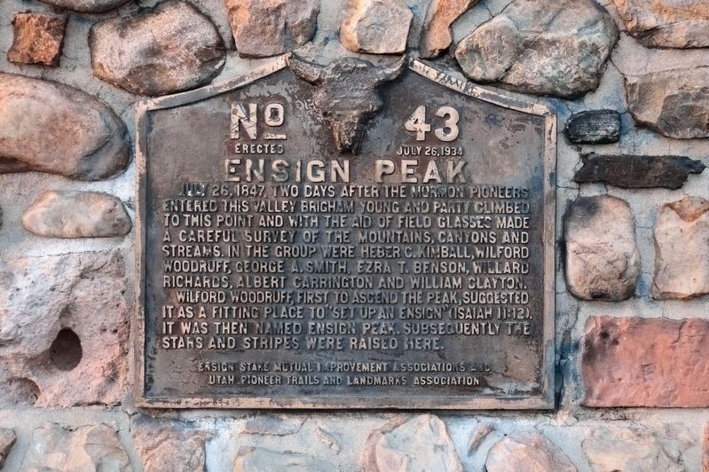
Wilford Woodruff, first to ascend the peak, suggested it as a fitting place to “set up an ensign” (Isaiah 11:12). It was then named Ensign Peak. Subsequently the Stars and Stripes were raised here.
Erected 1934 by Ensign Stake Mutual Improvement Associations and Utah Pioneer Trails Landmarks Association. (Marker Number 43.)
Topics and series. This historical marker is listed in these topic lists: Churches & Religion • Patriots & Patriotism • Settlements & Settlers. In addition, it is included in the Utah Pioneer Trails and Landmarks Association series list. A significant historical date for this entry is July 26, 1951.
Location. 40° 47.664′ N, 111° 53.442′ W. Marker is in Salt Lake City, Utah, in Salt Lake County. It is in Capitol Hill. Marker can be reached from Ensign Vista Drive west of East Greenstroke Drive. The marker is located in the Ensign Peak Nature Park and can be reached via a clearly marked 0.5 mile trail to the peak. Touch for map. Marker is at or near this postal address: 1002 N Ensign Vista Dr, Salt Lake City UT 84103, United States of America. Touch for directions.
Other nearby markers. At least 8 other markers are within walking distance of this marker. The Summit (here, next to this marker); Flags on Ensign Peak (here, next to this marker); The View (here, next to this marker); The Valley (about 400 feet away, measured in a direct line); a different marker also named The View (approx. 0.2 miles away); The American Indians (approx. 0.2 miles away); The Explorers (approx. 0.2 miles away); Welcome to Ensign Peak (approx. 0.2 miles away). Touch for a list and map of all markers in Salt Lake City.
More about this marker. A duplicate marker can be found at the bottom, at the Ensign Trailhead Plaza.
Also see . . .
1. Ensign Peak Park. Mormon Historic Sites Foundation (Submitted on July 7, 2011, by Bernard Fisher of Richmond, Virginia.)
2. Ensign Peak (pdf file). Mormon Historic Sites Foundation (Submitted on July 7, 2011, by Bernard Fisher of Richmond, Virginia.)
3. Article on the recovery of the marker in 1992. (Submitted on May 27, 2020.)

Photographed By Andrew Johnson, October 7, 2018
4. Ensign Peak Monument reverse
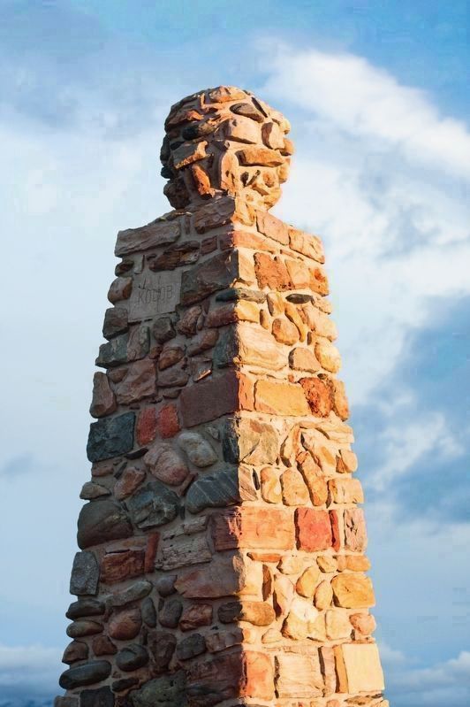
Embedded near the top of the north face of the monument, opposite the face containing the marker, is a cracked stone slab on which the word “Kolob” is inscribed. (Kolob is a star or planet described in the sacred text of the Latter Day Saints movement.)
Credits. This page was last revised on May 31, 2023. It was originally submitted on July 2, 2011, by Jack Duffy of West Jordan, Utah. This page has been viewed 1,423 times since then and 45 times this year. Last updated on May 26, 2020, by Tyler Thorsted of Orem, Utah. Photos: 1. submitted on October 15, 2018, by Andrew Johnson of Salt Lake City, Utah. 2. submitted on July 2, 2011, by Jack Duffy of West Jordan, Utah. 3, 4. submitted on October 15, 2018, by Andrew Johnson of Salt Lake City, Utah. • J. Makali Bruton was the editor who published this page.


