Sandy in Salt Lake County, Utah — The American Mountains (Southwest)
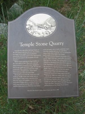
Temple Stone Quarry
Workers began quarrying the huge boulders on the canyon floor in 1861. That work continued almost nonstop for twenty-five years. Immigrants from Europe taught quarrymen to split off rocks into various sizes. Then teamsters hauled the rough-hewn stones to Temple Square, where expert stonecutters gave them their final shape.
Moving the stones from the canyon was a real challenge. Smaller stones were loaded onto ox-drawn wagons. Larger stones, some measuring three-feet square and weighing over two tons, could not be lifted. Workers drove a reinforced wagon over such a stone and dug trenches under the wheels until the frame rested on it. With the stone lashed under the frame, oxen or mules pulled the wagon out of the trenches and onto the road. Many wagons broke down under the stress of carrying that much weight twenty miles to the temple.
The slow transport delayed construction, so in the late 1860s crews dug a canal to float the stones to Salt Lake City on barges. This method did not work well and was abandoned when the railroad came to Utah. Beginning in 1871 the stones were hauled on flat cars from the railroad station in Sandy right onto Temple Square. In 1873 the Church and local miners built a narrow gauge railway up into the canyon. Some of today's main roads follow the routes pioneered by those stone-laden wagons and rails.
By the late 1880s the temple walls were up and activity at the quarries stopped. Stones from here have also been used for a few other structures, notably the Utah State Capitol Building and the “This is the Place” Monument. However, this site is still best known as the Temple Stone Quarry.
Erected 1994 by The Church of Jesus Christ of Latter-day Saints.
Topics. This historical marker is listed in these topic lists: Churches & Religion • Industry & Commerce • Roads & Vehicles. A significant historical year for this entry is 1861.
Location. 40° 34.296′ N, 111° 46.464′ W. Marker is in Sandy, Utah, in Salt Lake County. Marker can be reached from the intersection of East Little Cottonwood Road (Utah Route 209) and South Watsatch Boulevard (Utah Route 210). The marker is located along the Temple Quarry Trail in the Wasatch National Forest. Touch for map. Marker is in this post office area: Sandy UT 84092, United States of America. Touch for directions.
Other nearby markers. At least 8 other markers are within 2 miles of this marker, measured as the crow flies. Temple Quarry Amphitheater (a few steps from this marker); Welcome to the Temple Quarry Trail (within shouting distance of this marker); Your Roots (within shouting distance of this marker); Temple Granite Quarry (within shouting distance of this marker); a different marker also named Welcome to the Temple Quarry Trail (within shouting distance of this marker); Plugging into Water (about 300 feet away, measured in a direct line); Rocky Mountain Goat Lookout (about 400 feet away); Granite Settlement (approx. 1.6 miles away). Touch for a list and map of all markers in Sandy.
Credits. This page was last revised on June 16, 2016. It was originally submitted on July 4, 2011, by Jack Duffy of West Jordan, Utah. This page has been viewed 1,038 times since then and 20 times this year. Photo 1. submitted on July 4, 2011, by Jack Duffy of West Jordan, Utah. • Bernard Fisher was the editor who published this page.
Editor’s want-list for this marker. Wide area shot of the marker and its surroundings. • Can you help?
