Inver Grove Heights in Dakota County, Minnesota — The American Midwest (Upper Plains)
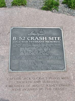
B-52 Crash Site
Cold War Veterans Memorial
Captain Wm. C. Horstman, pilot. Kansas City, MO
Captain Richard J. Cantwell, navigator. Phoenix, AZ
Major S. O. Gillespie, Jr., radar observer. Atlanta, GA
1st Lt. Wm. F. Huskey, engineer. Norman, OK
T/Sgt. Leon R. Lew, tail gunner. Skokie, IL
Captain James D. Taylor, instructor. Dixon, KY
Captain Benard D. Lanois, instructor. San Diego, CA
This marker has been erected in honor of the lost crewmen. Though from homes far away, and now long gone from this earth, they have not been forgotten by the citizens of Inver Grove Heights, the State of Minnesota, or the Country they so proudly served.
Supporting the Memorial:
The Minnesota Aviation Hall of Fame. Chaska
Planes of Fame East, Inc. Eden Prairie
Twin City Aero Historians. Minneapolis-St. Paul
Minnesota Air National Guard Historical Foundation. International Airport
American Wings Air Museum. Anoka County Airport
The Confederate Air Force, Southern Minnesota Wing. So. St. Paul
Air Force Association, E.W. Rawlings Chapter. St. Paul
Captain Jack D. Craft Purvis, Miss. injured and survived.
8 Members of August Kahl's Family were injured by the crash.
Erected 1996 by the Minnesota Aviation Hall of Fame, et al.
Topics. This historical marker is listed in these topic lists: Air & Space • War, Cold. A significant historical date for this entry is September 16, 1958.
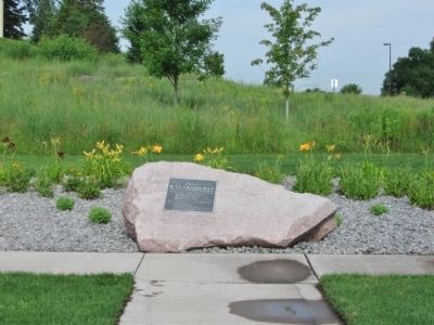
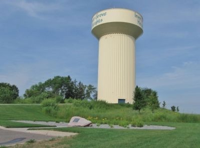
Location. 44° 49.285′ N, 93° 3.041′ W. Marker is in Inver Grove Heights, Minnesota, in Dakota County. Marker is on Broderick Boulevard north of Brooks Boulevard, on the left when traveling north. Marker is along the service road to the Inver Grove Heights water tower. Touch for map. Marker is in this post office area: Inver Grove Heights MN 55076, United States of America. Touch for directions.
Other nearby markers. At least 8 other markers are within 7 miles of this marker, measured as the crow flies. The Salem Evangelical Church (approx. 3˝ miles away); The Stockyards (approx. 4.6 miles away); Armour & Company (approx. 4.7 miles away); Swift & Company (approx. 5.1 miles away); 1914 Eagan Old Town Hall (approx. 5.7 miles away); Kaposia Village (approx. 6.4 miles away); Kaposia: Dakota Village on the Mississippi River (approx. 6.6 miles away); Local Stone, National Story (approx. 6.8 miles away).
Additional commentary.
1. Anna Goers Kahl
August and Anna Kahl are my aunt and uncle. August died some years ago but Anna just celebrated her 100th birthday this past weekend. Pretty remarkable!
— Submitted August 5, 2013, by Mary Manson of Jefferson City, Montana.
2. My step brother's dad was William Charlie Horstman
My Dad and his widowed Mom Wanda were married years ago and have since both passed away. I knew about the crash but didn't know about the memorial until Nick emailed me yesterday about it being 58 years ago that his Dad Charlie had been killed in the crash. Thanks for and to all who made this happen!
— Submitted January 22, 2019, by Michael H. Gerber of Altamonte Springs, Fl..
3. Eye Witness Account
I lived 6 miles northwest of the crash site. I was 10 years old staring out the bay window of my folks home on a dark night, then I saw a large fire ball in the sky, it looked like the size of a volleyball in the window. We drove there a few days later, the wreckage was gone but the hillside ground was scorched and black, at least and acre-size patch.
— Submitted April 29, 2022, by Joseph D. Sapletal Sr. of South Saint Paul, Mn..
4. Witnessed the crash of the B-52
A friend and I were in the parking lot of the Hilltop Drive-in theater located in Houlton Wisconsin near Stillwater Minnesota. Just prior to the movie starting there was a bright flash of light across the sky. It scared me because it was similar to the flash that occurs when an A-bomb explodes. My friend and I decided to find out what the cause of that flash of light was. We knew the general area that it occurred and we actually thought it was an explosion at the Pine Bend refinery. We kept driving toward the light of the fire caused when the plane crashed and.in spite of the main road to the crash site being blocked off, we were eventually able to get to the site by walking thru fields and forest. As we were walking to the site we came across one of the huge jet engines that had apparently separated from the plane when it crashed. The crash site was an incredible sight to see with what was left of the plane still burning and the barn and house on fire, too. As I recall, it appeared that the plane came in at an angle and not just straight down because the plane created a pretty wide trench as it crashed. I know there was one survivor and often wondered why the rest of the crew did not bail out. An unforgettable night and amazing that we were at least 25 miles from the crash site but still saw the flash of light from the crash.
— Submitted July 3, 2023, by Nile Kriesel of Stillwater, Minnesota.
Credits. This page was last revised on August 14, 2023. It was originally submitted on July 29, 2011, by Keith L of Wisconsin Rapids, Wisconsin. This page has been viewed 9,242 times since then and 479 times this year. Last updated on August 14, 2023, by McGhiever of Minneapolis, Minnesota. Photos: 1, 2, 3. submitted on July 29, 2011, by Keith L of Wisconsin Rapids, Wisconsin. • Bill Pfingsten was the editor who published this page.


