Mammoth in Yellowstone National Park in Park County, Wyoming — The American West (Mountains)
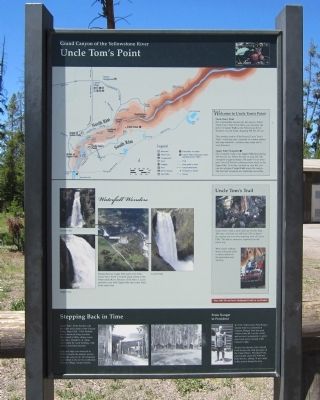
Uncle Tomís Point
Grand Canyon of the Yellowstone River
Welcome to Uncle Tomís Point
Uncle Tomís Trail
For a memorable descent into the canyon, follow Uncle Tomís Trail. From there, you can sense the power of Lower Falls as the Yellowstone River thunders over the brink, dropping 308 feet (93 m).
This modern version of the historic Uncle Tomís Trail—a trail that once consisted of wooden ladders and rope handrails—contains many steps and is very strenuous.
Upper Falls Viewpoint
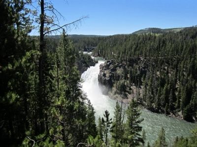
For a leisurely walk to see Upper Falls plummeting 109 feet (33 m), follow the trail on your left. The viewpoint is approximately 100 yards (90 m) from here. You will find two platforms from which to see Upper Falls. From the overlook on your left, you can also glimpse Crystal Falls across the canyon. The trail and viewpoint are wheelchair accessible.
Waterfall Wonders
Nestled between Upper Falls and Lower Falls, Uncle Tomís Point is located along a bend in the Yellowstone River. Because of the bend, it is not possible to see both Upper Falls and Lower Falls at the same time.
Uncle Tomís Trail
Uncle Tomís Trail, a steel stairway of more than 300 steps, will lead you 500 feet (150 m) below the canyon rim to an awe-inspiring view of Lower falls. The hike is strenuous, especially on the return trip.
Wear sturdy walking shoes with good tread to safely maneuver the perforated steel stairway.
Stay safe! Do not leave designated trails or overlooks!
(sidebar)
Stepping Back in Time
Uncle Tomís Point bustled with the sights and sounds of the Canyon Lodge from 1924 – 1956. Behind you stood an inviting structure that housed a lobby, dining room, and office. Hundreds of cabins surrounded the main building, with a horse corral beyond.
Canyon Lodge was removed in 1956 to restore the natural scenery along the canyon rim. Development was shifted to the newly established Canyon Village., located nearby.
From Ranger to President
In 1936, Yellowstone Park Ranger Gerald Ford was stationed at Canyon. Ranger Ford met park visitors from all over the world, and received assignments to greet renowned guests staying at the Canyon Lodge.
Nearly four decades later, Gerald Ford became the 38th president of the United States. President Ford cared deeply about the National Park Service, adding 18 new units to the system during his term.
This exhibit made possible by a generous grant from The Yellowstone Association
Erected by The Yellowstone Association.
Topics and series. This historical marker is listed in this topic list: Natural Features. In addition, it is included in the Former U.S. Presidents: #38 Gerald R. Ford, Jr. series list. A significant historical year for this entry is 1924.
Location. 44° 42.918′ N, 110° 29.783′ W. Marker is in Yellowstone National Park, Wyoming, in Park County. It is in Mammoth. Marker can be reached from South Rim Drive, 0.6 miles east of Grand Loop Road. Touch for map. Marker is in this post office area: Yellowstone National Park WY 82190, United States of America. Touch for directions.
Other nearby markers. At least 8 other markers are within walking distance of this marker. Uncle Tomís Trail (about 500 feet away, measured in a direct line); Upper Falls of the Yellowstone River (about 600 feet away); Geologic Junction (about 600 feet away); Brink of Upper Falls (approx. ľ mile away); Brink of Lower Falls (approx. 0.3 miles away); Still Venting After All These Years (approx. 0.3 miles away); Waterfall Makers (approx. 0.6 miles away); Chittenden Memorial Bridge (approx. 0.6 miles away). Touch for a list and map of all markers in Yellowstone National Park.
Also see . . . Yellowstone National Park. National Park Service (Submitted on July 30, 2011.)
Credits. This page was last revised on February 16, 2023. It was originally submitted on July 30, 2011, by Bernard Fisher of Richmond, Virginia. This page has been viewed 1,051 times since then and 36 times this year. Photos: 1, 2, 3. submitted on July 30, 2011, by Bernard Fisher of Richmond, Virginia.


