Near Avery in Shoshone County, Idaho — The American West (Mountains)
A Changing Landscape
“Change is inevitable. Change is constant.” Benjamin Disraeli
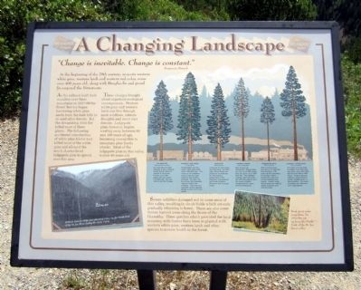
At the beginning of the 20th century, majestic western white pine, western larch and western red cedar, some over 400 years old, along with Douglas-fir and grand fir carpeted the Bitterroots.
As the railroad built their mainline over these mountains in 1907-09 the Forest Service began harvesting white pine seeds from the lush hills to re-seed other forests. But the devastating 1910 fire killed most of these giants. The following accidental introduction of white pine blister rust killed most of the white pine and allowed the much shorter-lived lodgepole pine to spread over this area.
These changes brought about important ecological consequences. Western white pine and western larch can live through most wildfires, tolerate droughts and resist root disease. Lodgepole pine, however, begins wasting away between 80 and 100 years of age, becoming susceptible to mountain pine beetle attacks. Most of the lodgepole pine in this valley is over 80 years old.
Severe wildfires damaged soil in some areas of this valley, resulting in shrub fields which are only gradually returning to forest. There are also some timber harvest areas along the Route of the Hiawatha. These patches which provided the local economy with timber have been re-planted with western white pine, western larch and other species to restore health to the forest.
(sidebar)
Douglas-fir
Pseudotsuga menziesii
An important timber species, it has a strong wood and is used for veneer in plywood. It lives up to 300 years and can reach 170 feet tall. Grouse like to eat the foliage.
western red cedar
Thuja plicata
These trees can live over 1,000 years and reach 160 feet toll. The wood is rot resistant and is used for boat building and roofing shingles. Its bark can be woven into baskets, nets and fabric for clothing. This tree is a member at the cypress family, so it’s not a true cedar.
grand fir
Abies grandis
Living up to 250 years and reaching 160 feet high, these trees are prized by woodsmen for the healing properties of the fragrant, transparent gum resin blisters found on the younger trees.
western larch
Larix occidentalis
Also known as “tamarack,” these trees can live up to 500 years and can grow up to 200 feet tall. The needles change color and drop off with the season and its wood is highly sought as hot, clean burning firewood.
lodgepole pine
Pinus contorta
This common tree can grow 100 feet tall and live 80 to 100 years at this elevation in northern Idaho. Forest fire opens its cones releasing the seeds. Indians used these trees for making tepee supports and travols poles.
western white pine
Pinus monticola
If it does not succumb to blister rust, this tree can grow up to 230 feet tall and live 300 to 400 years. It has a strong, uniform wood without knots, twisted grain or discoloration. Its wood is perfect for millwork and matchsticks.
Topics. This historical marker is listed in these topic lists: Disasters • Horticulture & Forestry • Railroads & Streetcars. A significant historical year for this entry is 1910.
Location. 47° 21.652′ N, 115° 40.073′ W. Marker is near Avery, Idaho, in Shoshone County. Marker can be reached from Cliff Creek Road (Federal Road 506) 2.6 miles north of Loop Creek Road (Federal Road 326). Located along the Route of the Hiawatha Trail. Touch for map. Marker is in this post office area: Avery ID 83802, United States of America. Touch for directions.
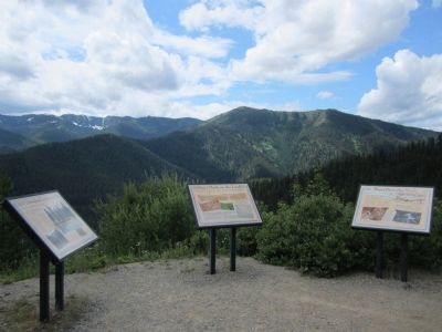
Other nearby markers. At least 8 other markers are within walking distance of this marker. Man’s Mark on the Land (a few steps from this marker); Water Does the Work! (a few steps from this marker); Temporary Trestles (approx. 0.7 miles away); Tunneling Toward Tacoma (approx. 0.7 miles away); The Toughest Town (approx. 0.9 miles away); World Class Workers (approx. 0.9 miles away); Secluded Falcon (approx. 0.9 miles away); "In the Hole" (approx. 0.9 miles away). Touch for a list and map of all markers in Avery.
More about this marker. On the lower left is a photo with the caption, "A Forest Service white pine planting camp on the North Fork of the St. Joe River during the early 1920s." USDA Forest Service photograph
On the lower right is a photo of "Dead giant cedar snags from the 1910 fire jut up from the North Fork of the St. Joe River valley." Jim Hughes Photograph
Also see . . . Route of the Hiawatha Rail Trail. (Submitted on August 4, 2011, by Bernard Fisher of Richmond, Virginia.)
Credits. This page was last revised on October 21, 2020. It was originally submitted on August 4, 2011, by Bernard Fisher of Richmond, Virginia. This page has been viewed 737 times since then and 5 times this year. Photos: 1, 2. submitted on August 4, 2011, by Bernard Fisher of Richmond, Virginia.

