Avery in Shoshone County, Idaho — The American West (Mountains)
Mountains of Copper?
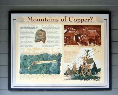
Depending on who you talk to, the hills around you contain either rich copper deposits or a lot of hot air....
Between 1889 and 1922, miners explored a number of promising mining properties near Adair. They encountered ore containing copper, sprinkled with small amounts of gold and silver.
Until 1910, the ore was hauled on wagons over the Bitterroot Mountains to the Northern Pacific Railroad Station at Saltese, Montana.
During World War I copper prices soared, spurring development of the marginal deposits in the Richmond and Monitor Mines. After 1918, the price of copper plummeted and the Richmond soon closed.
Hopeful miners, however, continued to explore the Monitor Mine. They dug a two-mile tunnel from just above Adair to a point under the existing mine, but failed to find any commercial ore. Today miners are still working these hills, hoping that one day...
(sidebar)
An 8,800 foot cable tram system was built from the Richmond Mine to Adair in 1916 by the Ribel Aerial Tramway Company of Spokane, Washington. It could haul 240 tons a day, but never exceeded 50 tons a day.
The aerial tramway lasted only until 1919. Although the towers rotted and collapsed, some of the tram line and damaged ore buckets can still be found along the line.
Topics. This historical marker is listed in these topic lists: Industry & Commerce • Railroads & Streetcars. A significant historical year for this entry is 1889.
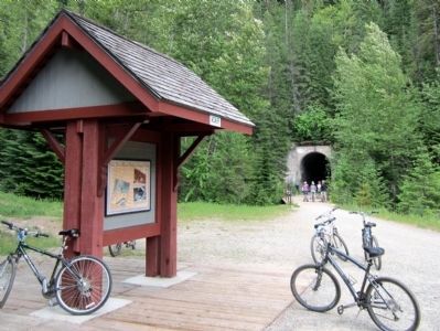
Location. 47° 20.527′ N, 115° 36.459′ W. Marker is in Avery, Idaho, in Shoshone County. Marker can be reached from Loop Creek Road (Federal Road 326) 4 miles west of Cliff Creek Road (Federal Road 506). Located along the Route of the Hiawatha Trail. Touch for map. Marker is in this post office area: Avery ID 83802, United States of America. Touch for directions.
Other nearby markers. At least 8 other markers are within one mile of this marker, measured as the crow flies. This Place Had a Name? (here, next to this marker); Signs, Wires & Whistles (approx. 0.4 miles away); Milwaukee Road Muscle (approx. 0.6 miles away); Electrified (approx. 0.6 miles away); The Traveler (approx. 0.8 miles away); Johnson’s Big Cut (approx. 0.8 miles away); The Mighty Quills (approx. one mile away); Olympian Luxury (approx. 1.1 miles away). Touch for a list and map of all markers in Avery.
More about this marker. On the top left is a photo with the caption,
Malachite, Green Copper Carbonate"
On the bottom is a drawing with the caption, "This is a bird’s eye view of Adair and the nearby mines. The original Monitor Shaft (A) was excavated between 1897 and 1910. In 1914, a tunnel was excavated (B) from Adair two miles to a point under the original Monitor Shaft. By 1924, the tunnel had been dug to a distance of 9,400 feet and had creates a huge tailings pile (C). In 1916, a tramway (D) was constructed to bring or down from the Richmond Mine to the siding at Adair."
On the upper right is a photo with the caption, "Day shift just out of the long tunnel of the Monitor Mine circa 1920."
Also see . . . Route of the Hiawatha Rail Trail. (Submitted on August 5, 2011, by Bernard Fisher of Richmond, Virginia.)
Credits. This page was last revised on June 16, 2016. It was originally submitted on August 5, 2011, by Bernard Fisher of Richmond, Virginia. This page has been viewed 598 times since then and 15 times this year. Photos: 1, 2. submitted on August 5, 2011, by Bernard Fisher of Richmond, Virginia.

