Near Avery in Shoshone County, Idaho — The American West (Mountains)
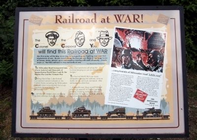
Railroad at WAR!
The Milwaukee Road transported tons of war material and thousands of troops during World Wars I and II, the Korean War and the Vietnam War.
During World War I, the Federal Government seized railroads in the United States including the Milwaukee. One old-timer remembered that at age fourteen, he was hired by the Milwaukee to:
“…see that the bridges were not blown up from sabotage from the Germans… They had watchmen all along the railroad keeping on eye on tunnels and bridges.”
The Second World War saw many railroaders joining the military, even as traffic on the railroads increased. One railroader recalled that:
“…during the war, there weren't enough of us to go around, we had to just keep working, working, working to where sometimes I’d work as much as 40 to 50 eight-hour days a month…”
(sidebar)
The Colonel
the Corporal
and You
will find this Railroad at WAR
Our first order of the day, every day, is transporting our fighting men and their implements of war. As you travel along the line you are likely to see long trains of troops, tanks, planes, guns and supplies moving with swift efficiency - ample evidence that this railroad is very earnestly at war.
from: Milwaukee Road 1944 advertisement
(sidebar)
…compliments of Milwaukee road “white coal”
Allied bombers are raining ruin on the stronghold of the Axis, wrecking war production centers, transportation facilities, docks and warehouses. Do you realize that the fuel The Milwaukee Road is conserving by using “White Coal” may be helping to deal those devastating blows?
This “White Coal” is electricity from mountain water power, used for years to move Milwaukee Road trains across the Rockies, Bitter Roots and Cascades.
How fortunate that this electrification was functioning with proved efficiency when war came! It conserves millions of gallons of oil to help provide America’s ever-growing air armadas with needed flying power!
With a vast network of lines reaching from the dynamic Midwest to the vital ocean ports of the Pacific Northwest, The Milwaukee Road is now handling a traffic volume never approached before.
Modernized operating methods - plus the active cooperation of shippers and essential travelers - enable The Milwaukee Road’s 35,000 loyal, alert employees to do their full share for victory.
The Milwaukee Road
Electrified over the Rockies to the sea
from: Milwaukee Road 1944 advertisement
Topics. This historical marker is listed in these topic lists: Railroads & Streetcars • War, World II. A significant historical year for this entry is 1944.
Location. 47° 21.457′ N, 115° 42.306′ W. Marker is near Avery, Idaho, in Shoshone County. Marker can be reached from Moon Pass Road (Federal Road 456) 0.4 miles south of Loop Creek Road (Federal Road 326). Located along the Route of the Hiawatha Trail. Touch for map. Marker is in this post office area: Avery ID 83802, United States of America. Touch for directions.
Other nearby markers. At least 8 other markers are within 2 miles of this marker, measured as the crow flies. You want to be a Ranger? (approx. 0.4 miles away); Laboring in Luxury (approx. half a mile away); Smooth as Silk (approx. 0.7 miles away); Rough Roads & Wrecks (approx. one mile away); Bumps on the Milwaukee Road (approx. 1.2 miles away); Secluded Falcon (approx. 1.4 miles away); The Toughest Town (approx. 1.4 miles away); "In the Hole" (approx. 1.4 miles away). Touch for a list and map of all markers in Avery.
Also see . . . Route of the Hiawatha Rail Trail. (Submitted on August 5, 2011, by Bernard Fisher of Richmond, Virginia.)
Credits. This page was last revised on June 16, 2016. It was originally submitted on August 5, 2011, by Bernard Fisher of Richmond, Virginia. This page has been viewed 748 times since then and 13 times this year. Photos: 1, 2. submitted on August 5, 2011, by Bernard Fisher of Richmond, Virginia.

