Cascade near Colorado Springs in El Paso County, Colorado — The American Mountains (Southwest)
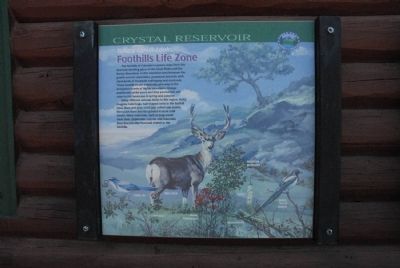
Take a Closer Look...Foothills Life Zone
Many different animals thrive in this region. Noisy magpies build huge, ball-shaped nests in the foothill trees. Blue-and-gray scrub jays collect oak acorns, then push them into the ground to store until winter. Many mammal, such as long eared mule deer, chipmunks, coyotes and mountain lions find plentiful food and shelter in the foothills.
Topics. This historical marker is listed in these topic lists: Animals • Environment.
Location. 38° 55.301′ N, 105° 1.549′ W. Marker is near Colorado Springs, Colorado, in El Paso County. It is in Cascade. Marker is on Pike's Peak Toll Road. Marker is located near the Crystal Reservoir Visitor Center. Touch for map. Marker is in this post office area: Cascade CO 80809, United States of America. Touch for directions.
Other nearby markers. At least 8 other markers are within 3 miles of this marker, measured as the crow flies. Well-traveled Water (here, next to this marker); Test Your Bird I.Q. (here, next to this marker); The Making of America's Mountain (here, next to this marker); A Mountain of Many Names (here, next to this marker); Take a Closer Look...Montane Life Zone (here, next to this marker); Take a Closer Look...Alpine/Subalpine Life Zone (here, next to this marker); Pick a Climate (here, next to this marker); Welcome to America’s Mountain (approx. 2.4 miles away). Touch for a list and map of all markers in Colorado Springs.
Credits. This page was last revised on January 19, 2024. It was originally submitted on August 10, 2011, by Charles T. Harrell of Woodford, Virginia. This page has been viewed 800 times since then and 14 times this year. Photos: 1, 2. submitted on August 10, 2011, by Charles T. Harrell of Woodford, Virginia. • Bill Pfingsten was the editor who published this page.

