Rocky Hill in Hartford County, Connecticut — The American Northeast (New England)
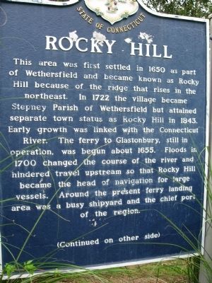
Rocky Hill
This area was first settled in 1650 as part of Wethersfield and became known as Rocky Hill because of the ridge that rises in the northeast. In 1722 the village became Stepney Parish of Wethersfield but attained separate town status as Rocky Hill in 1843. Early growth was linked with the Connecticut River. The ferry to Glastonbury, still in operation, was begun about 1655. Floods in 1700 changed the course of the river and hindered travel upstream so that Rocky Hill became the head of navigation for large vessels. Around the present ferry landing area was a busy shipyard and the chief port of the region.
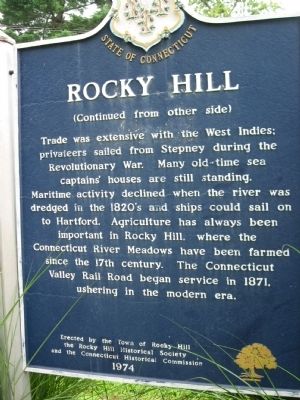
Trade was extensive with the West Indies; privateers sailed from Stepney during the Revolutionary War. Many old-time sea captains' houses are still standing. Maritime activity declined when the river was dredged I the 1820's and ships could sail on to Hartford. Agriculture has always been important in Rocky Hill, where the Connecticut River Meadows have been farmed since the 17th century. The Connecticut Valley Rail Road began service in 1871, ushering in the modern era.
Erected 1974 by the Town of Rocky Hill, the Rocky Hill Historical Society, the Connecticut Historical Commission.
Topics. This historical marker is listed in these topic lists: Colonial Era • Settlements & Settlers. A significant historical year for this entry is 1650.
Location. 41° 40.065′ N, 72° 38.221′ W. Marker is in Rocky Hill, Connecticut, in Hartford County. Marker is at the intersection of Old Main Street and Riverview Road, on the right when traveling south on Old Main Street. Touch for map. Marker is in this post office area: Rocky Hill CT 06067, United States of America. Touch for directions.
Other nearby markers. At least 8 other markers are within walking distance of this marker. Rocky Hill - A CT River Town (about 600 feet away, measured in a direct line); Academy Hall (about 700 feet away); Farming in Rocky Hill (about 700 feet away); Rocky Hill Center Historic District (approx. 0.2 miles away); Elm Street Historic District (approx. 0.3 miles away); Historic Ground (approx. 0.3 miles away); Rocky Hill-Glastonbury Ferry Historic District (approx. 0.3 miles away); State Historic Landmark (approx. 0.4 miles away). Touch for a list and map of all markers in Rocky Hill.
Also see . . . Rocky Hill, Connecticut on Wikipedia. (Submitted on August 17, 2011, by Michael Herrick of Southbury, Connecticut.)
Credits. This page was last revised on October 11, 2022. It was originally submitted on August 17, 2011, by Michael Herrick of Southbury, Connecticut. This page has been viewed 673 times since then and 21 times this year. Photos: 1, 2, 3, 4. submitted on August 17, 2011, by Michael Herrick of Southbury, Connecticut.


