Perryville in Boyle County, Kentucky — The American South (East South Central)
Introduction
Perryville • The Battle For Kentucky
— October 8, 1862 —
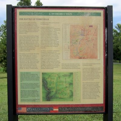
The Battle of Perryville
In the summer of 1862, Confederate General Braxton Bragg’s Army of the Mississippi invaded Kentucky. Bragg hoped to enlist recruits, pull Union troops out of Tennessee, and hold Kentucky for the Confederacy. With these objectives in mind, the Confederate army entered the Bluegrass State.
Union soldiers reacted quickly to Bragg’s invasion. Moving from Nashville, Union General Don Carlos Buell’s Army of the Ohio rushed to Kentucky. Realizing that Bragg could capture Louisville, a major supply depot, Buell marched his army to that city. Here, Buell enlisted recruits and advanced on the Confederates. When the 58,000 Union soldiers pressed the Confederates at Bardstown, they withdrew to Perryville.
For months, a severe drought affected the area, and both sides were in need of water. The Confederates, camping in Perryville on the night of October 7, placed an advance guard west of town, near Doctor’s Creek. When Union forces reached the area, they learned that small pools of water were available in the creek. Union troops were ordered to capture the water and the nearby high ground. At 3:00 a.m., Federal soldiers moved on Peter’s Hill, and forced back the Confederates.
Bragg was ten miles away in Harrodsburg when he learned that Union soldiers were in Perryville. Thinking this was a minor Federal force, Bragg ordered the Confederates to attack. The assault never happened, and Bragg rushed to Perryville to learn why his orders were disobeyed. His staff had chosen a defensive strategy, so Bragg again ordered his 16,000 troops to attack. Little did he know that 20,000 Union troops were south of Perryville, 20,000 were west of town, and 18,000 were north of Perryville, forming on these hills.
At 2:00 p.m. on October 8, Benjamin F. Cheatham’s Confederate division crossed the dry Chaplin River and struck Alexander McCook’s corps of Union soldiers, who were positioned on these ridges. Encountering heavy resistance from Federal artillery and infantry, Cheatham’s soldiers attacked the northern end of McCook’s line. To the south, Simon B. Buckner’s Confederates hit McCook’s right flank, located above the H. P. Bottom House. The element of surprise greatly aided the Confederate attack.
Both ends of the Union line were bent back toward the Russell House, which served as McCook’s headquarters. Reforming their lines near the structure, Union reinforcements helped check the Confederate advance. As Buckner and Cheatham drove back McCook’s corps, Confederate Colonel Samuel Powell’s brigade attacked Charles Gilbert’s III corps, located west of town. Outnumbered, Powell was easily repulsed by the Union soldiers. Although Powell was forced back, his actions delayed reinforcements from joining McCook’s corps.
The Confederates had won a tactical victory, but encountered a strategic defeat. Although the Confederates whipped the Federal left, Bragg finally realized he was outnumbered. The Southerners eventually left the state, ending the invasion and dashing the hopes of a Confederate Kentucky. The Battle of Perryville, which was Kentucky’s largest Civil War battle, killed and wounded more than 7,500 Union and Confederate troops.
(sidebar)
Trail Information
Interpretation at the Perryville Battlefield State Historic Site is divided into two loop trails. The Primary Trail Loop (approx. walking time 1 hour) features interpretive sites 3 through 12, presenting the attacks of the Confederate Generals Maney, Donelson, and Stewart upon the Union defensive lines.
The Extended Trail Loop (approx. walking time 1 hour, 15 minutes) features interpretive sites 13 through 22, presenting the attacks of the Confederate Generals Jones, Brown and Cleburne as well as the artillery duels from Loomis Heights.
Alternatively, you may wish to follow the trail system along the routes of Confederate attack. Maney’s attack is presented by sites 5, 6, 7, 8, and 9; Donelson’s attack by sites 3, 12, and 11; Stewart attack by sites 4 and 10; Jones’ attack by sites 15, 16, and 17; and Cleburne’s attack by sites 19, 20, and 21.
We hope you enjoy your tour. Please stay on the trails and help us protect this battlefield.
Topics. This historical marker is listed in this topic list: War, US Civil. A significant historical date for this entry is October 8, 1862.
Location. 37° 40.448′ N, 84° 58.184′ W. Marker is in Perryville, Kentucky, in Boyle County. Marker is on Park Road, 0.3 miles west of Battlefield Road (Kentucky Route 1920). Located in Perryville Battlefield State Historic Site. Touch for map. Marker is at or near this postal address: 1825 Battlefield Road, Perryville KY 40468, United States of America. Touch for directions.
Other nearby markers. At least 8 other markers are within walking distance of this marker. Soldiers' Reaction to Lincoln's Emancipation (about 300 feet away, measured in a direct line); Perryville and the Emancipation Proclamation (about 300 feet away); Confederate Cemetery (about 300 feet away); Squire Henry P. Bottom (about 300 feet away); Perryville Confederate Memorial (about 400 feet away); Donelson's Advance (about 400 feet away); The Valley of Death (about 400 feet away); Perryville Battlefield (about 400 feet away). Touch for a list and map of all markers in Perryville.
Credits. This page was last revised on November 2, 2021. It was originally submitted on August 23, 2011, by Bernard Fisher of Richmond, Virginia. This page has been viewed 652 times since then and 14 times this year. Photo 1. submitted on August 23, 2011, by Bernard Fisher of Richmond, Virginia.
