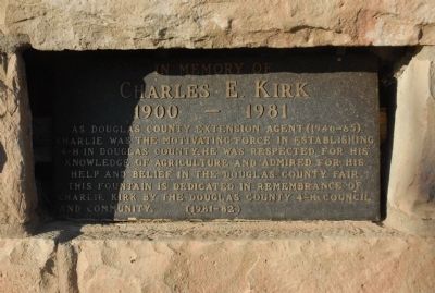
Lakota Hills near Golden in Jefferson County, Colorado — The American Mountains (Southwest)
Charles E. Kirk
Topics and series. This historical marker is listed in these topic lists: Agriculture • Charity & Public Work. In addition, it is included in the 4-H Youth Program series list.
Location. 39° 43.972′ N, 105° 14.31′ W. Marker is near Golden, Colorado, in Jefferson County. It is in Lakota Hills. Marker is on Lariat Loop Road. Marker is located on path from the Buffalo Bill Museum to the grave of Buffalo Bill Cody. Touch for map. Marker is in this post office area: Golden CO 80401, United States of America. Touch for directions.
Other nearby markers. At least 8 other markers are within walking distance of this marker. Lariat Loop Byway: Buffalo Bill Museum (within shouting distance of this marker); Lariat Loop Byway: Denver Mountain Parks (within shouting distance of this marker); Who Was Buffalo Bill? (within shouting distance of this marker); Buffalo Bill's Grave — Frequently Asked Questions (within shouting distance of this marker); Buffalo Bill's Grave — Why is Buffalo Bill Buried Here? (within shouting distance of this marker); Buffalo Bill (within shouting distance of this marker); Our Changing Landscape-From Sea Floor to Mountain Top (about 300 feet away, measured in a direct line); What You Can See From Here Today (about 300 feet away). Touch for a list and map of all markers in Golden.
Credits. This page was last revised on February 7, 2023. It was originally submitted on August 27, 2011, by Charles T. Harrell of Woodford, Virginia. This page has been viewed 726 times since then and 14 times this year. Photo 1. submitted on August 27, 2011, by Charles T. Harrell of Woodford, Virginia. • Bill Pfingsten was the editor who published this page.
