New Franklin in Howard County, Missouri — The American Midwest (Upper Plains)
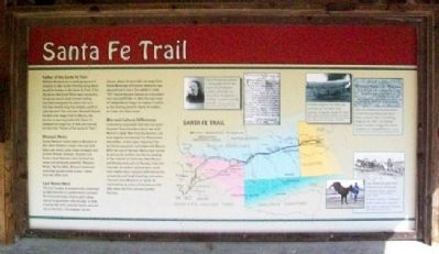
Santa Fe Trail
Father of the Santa Fe Trail
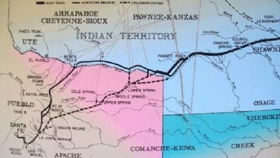
William Becknell led a small group out of Franklin in 1821 on the first trip along what would be known as the Santa Fe Trail. If his trip across the Great Plains was successful, the group would make money trading manufactured goods for silver and furs. This four-month-long trip netted a profit of 1,500 percent. The next year, Becknell blazed the 800-mile wagon trail to Mexico. His success in opening trade with Santa Fe allowed him to get out of debt and earned him the title "Father of the Santa Fe Trail."
Missouri Mules
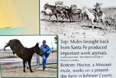
Sturdy Mexican mules came to Missouri in 1823 when Stephen Cooper returned with about 400 mules, jacks (male donkeys) and jennets (female donkeys). Boone's Lick farmers bred Mexican jacks to American mares and produced powerful "Missouri Mules." By the 1880s, Missouri produced more than 34,000 mules a year - more than any other state.
East Moves West
The trail became so economically important by 1825 that the U.S. government surveyed the route and made treaties with Indian nations to guarantee safe passage. In 1826, a young man with untested talents also set out on the trail - Christopher Carson.
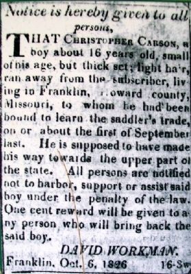
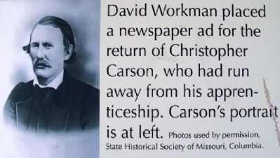
Carson, about 16 years old, ran away from David Workman of Franklin where he was apprentices to learn the saddler's trade. "Kit" Carson became famous as a mountain man and pathfinder. In 1827, the new town of Independence began to replace Franklin as the starting point for Santa Fe traders, as it was 100 miles closer.
War and Cultural Differences
Controversy associated with the trail and a disputed Texas boundary led to war with Mexico in 1846. Men from the Boone's Lick area eagerly volunteered. For Missourians and others, victory was important for territorial expansion and trade with Mexico. With the loss of the war, Mexico was forced to give up its northern territories, leading to the creation of California, New Mexico and Arizona and parts of Nevada, Utah and Colorado. As settlers pushed west, small-time traders were replaced with mercantile companies and freight-hauling contractors. The trail from Missouri to Santa Fe continued as an artery of commerce until 1880 when the first railroad reached the area.
Erected by Missouri Department of Natural Resources.
Topics and series. This historical marker is listed in these topic lists: Industry & Commerce • Roads & Vehicles • Settlements & Settlers • War, Mexican-American. In addition, it is included in the Santa Fe Trail series list. A significant historical year for this entry is 1821.
Location. 39° 0.749′ N, 92° 44.14′ W. Marker
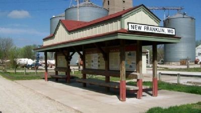
is in New Franklin, Missouri, in Howard County. Marker is at the Katy Trail State Park kiosk (Mile Post 188) at the south end of Howard Street, about 500 feet east of Missouri Street (Missouri Route 5). Touch for map. Marker is in this post office area: New Franklin MO 65274, United States of America. Touch for directions.
Other nearby markers. At least 8 other markers are within walking distance of this marker. History of New Franklin (here, next to this marker); The New Franklin Viaduct (about 500 feet away, measured in a direct line); KATY Caboose #127 (approx. 0.3 miles away); Franklin (approx. 0.3 miles away); Franklin and New Franklin (approx. 0.3 miles away); End of Boone's Lick Trail (approx. 0.3 miles away); City of Trails (approx. 0.3 miles away); Santa Fe Trail Marker (approx. 0.3 miles away). Touch for a list and map of all markers in New Franklin.
Also see . . .
1. Santa Fe National Historic Trail. National Park Service website entry (Submitted on September 7, 2011, by William Fischer, Jr. of Scranton, Pennsylvania.)
2. Santa Fe Trail Association. Association website entry (Submitted on September 7, 2011, by William Fischer, Jr. of Scranton, Pennsylvania.)
3. William Becknell. Santa Fe Trail History website entry (Submitted on September 7, 2011, by William Fischer, Jr. of Scranton, Pennsylvania.)
4. Kit Carson – Legend of the Southwest. Legends of America website entry (Submitted on September 7, 2011, by William Fischer, Jr. of Scranton, Pennsylvania.)
5. The Missouri Mule. Show Me Missouri website entry (Submitted on May 1, 2022, by Larry Gertner of New York, New York.)
6. Katy Trail State Park. Missouri State Parks website entry (Submitted on September 7, 2011, by William Fischer, Jr. of Scranton, Pennsylvania.)
Photographed By Unknown, undated
4. Photos on Santa Fe Trail Marker
[Caption reads] Top: Mules brought back from Santa Fe produced important work animals. Used by permission, State Historical Society of Missouri, Columbia.
Bottom: Hector, a Missouri mule, works on a present-day farm in Johnson County. Photo courtesy of Doug Tucker and Hector.
Bottom: Hector, a Missouri mule, works on a present-day farm in Johnson County. Photo courtesy of Doug Tucker and Hector.
Photographed By Unknown, undated
5. Photo on Santa Fe Trail Marker
[Caption reads] David Workman placed a newspaper ad for the return of Christopher Carson, who had run away from his apprenticeship. Carson's portait is at left. Photos used by permission of State Historical Society of Missouri, Columbia.
Photographed By Unknown, undated
7. Photo on Santa Fe Trail Marker
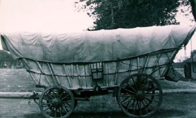
[Caption reads] Freight wagons like this one traveled on the 800-mile journey along the Santa Fe Trail. Photo courtesy of Jean Tyree Hamilton, from Arrow Rock: Where Wheels Started West. Used by permission, State Historical Society of Missouri, Columbia.
Photographed By Unknown, circa 1859
8. Ad on Santa Fe Trail Marker
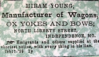
[Caption reads] African-American businessman Hiram Young employed more than a dozen men in building wagons. In 1867, he helped found a public school for black children in Independence. Courtesy of Jackson County Historical Society, Independence, Mo.
Credits. This page was last revised on May 1, 2022. It was originally submitted on September 7, 2011, by William Fischer, Jr. of Scranton, Pennsylvania. This page has been viewed 1,236 times since then and 31 times this year. Photos: 1, 2, 3, 4, 5, 6, 7, 8. submitted on September 7, 2011, by William Fischer, Jr. of Scranton, Pennsylvania.
