St. Joseph in Buchanan County, Missouri — The American Midwest (Upper Plains)
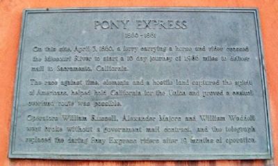
Pony Express
1860 - 1861
On this site, April 3, 1860, a ferry carrying a horse and rider crossed the Missouri River to start a 10 day journey of 1,966 miles to deliver mail to Sacramento, California.
The race against time, elements and a hostile land captured the spirit of Americans, helped hold California for the Union and proved a central overland route was possible.
Operators William Russell, Alexander Majors and William Waddell went broke without a government mail contract, and the telegraph replaced the daring Pony Express riders after 19 months of operation.
Topics and series. This historical marker is listed in these topic lists: Communications • Roads & Vehicles • Settlements & Settlers. In addition, it is included in the Pony Express National Historic Trail series list. A significant historical date for this entry is April 3, 1860.
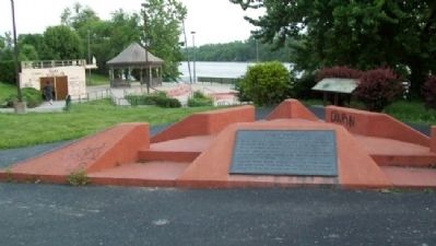
Location. 39° 45.98′ N, 94° 51.651′ W. Marker is in St. Joseph, Missouri, in Buchanan County. Marker is in the Missouri riverfront park, accessed via Francis Street, and about 200 yards southwest of the I-229 Exit 6A ramps. Touch for map. Marker is in this post office area: Saint Joseph MO 64501, United States of America. Touch for directions.
Other nearby markers. At least 8 other markers are within walking distance of this marker. Joseph Robidoux (here, next to this marker); The California - Oregon Trail (here, next to this marker); St. Michael's Prairie / The Lewis and Clark Expedition (a few steps from this marker); a different marker also named Pony Express (approx. 0.2 miles away); The Journey West (approx. ¼ mile away); Missouri Valley Trust Company (approx. 0.3 miles away); The Boder Building (approx. 0.3 miles away); Buchanan County Courthouse (approx. 0.4 miles away). Touch for a list and map of all markers in St. Joseph.
Also see . . .
1. Pony Express National Historic Trail. National Park Service website entry (Submitted on September 22, 2011, by William Fischer, Jr. of Scranton, Pennsylvania.)
2. National Pony Express Association. Organization website homepage (Submitted on September 22, 2011, by William Fischer, Jr. of Scranton, Pennsylvania.)
3. Pony Express Historical Timeline. Pony Express National Museum website entry (Submitted on September 22, 2011, by William Fischer, Jr. of Scranton, Pennsylvania.)
Credits. This page was last revised on April 26, 2022. It was originally submitted on September 22, 2011, by William Fischer, Jr. of Scranton, Pennsylvania. This page has been viewed 724 times since then and 16 times this year. Photos: 1, 2. submitted on September 22, 2011, by William Fischer, Jr. of Scranton, Pennsylvania.

