Near Pittsburg in Camp County, Texas — The American South (West South Central)
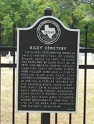
Riley Cemetery
Erected 1991 by Texas Historical Commission. (Marker Number 9807.)
Topics. This historical marker is listed in this topic list: Cemeteries & Burial Sites. A significant historical year for this entry is 1859.
Location. 32° 54.586′ N, 94° 46.127′ W. Marker is near Pittsburg, Texas, in Camp County. Marker can be reached from Farm to Market Road 557, 0.4 miles north of County Road 4430, on the right when traveling north. Cemetery located at County Line Baptist Church. Touch for map. Marker is in this post office area: Pittsburg TX 75686, United States of America. Touch for directions.
Other nearby markers. At least 8 other markers are within 9 miles of this marker, measured as the crow flies. Site of Old Spearman's Ferry (approx. 3.2 miles away); In Appreciation (approx. 3.4 miles away); Old Hughes Furnace (approx. 3.4 miles away); Iron Bluff Cemetery (approx. 3.9 miles away); C.S.A. Camp Talley (approx. 5 miles away); Old Coffeeville, C. S. A. (approx. 5 miles away); Tarver's Ferry (approx. 5.4 miles away); Caddo Trace (approx. 8.6 miles away).
Also see . . . Riley Cemetery. Find A Grave (Submitted on December 1, 2011, by Bernard Fisher of Richmond, Virginia.)
Additional keywords. Texas pioneers
Credits. This page was last revised on June 16, 2016. It was originally submitted on October 5, 2011, by Dan Keeling of Lafayette, Louisiana. This page has been viewed 1,164 times since then and 33 times this year. Photo 1. submitted on October 5, 2011, by Dan Keeling of Lafayette, Louisiana. • Bernard Fisher was the editor who published this page.
Editor’s want-list for this marker. A wide shot of the marker and its surroundings. • Can you help?
