Dedham in Norfolk County, Massachusetts — The American Northeast (New England)
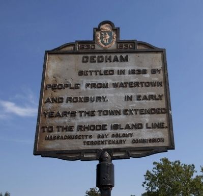
Dedham
1630 - 1930
Erected 1930 by Massachusetts Bay Colony-Tercentenary Commission.
Topics and series. This historical marker is listed in these topic lists: Colonial Era • Settlements & Settlers. In addition, it is included in the Massachusetts Bay Colony—Tercentenary Commission Markers series list. A significant historical year for this entry is 1636.
Location. 42° 14.875′ N, 71° 10.335′ W. Marker is in Dedham, Massachusetts, in Norfolk County. Marker is at the intersection of Eastern Avenue and High Street, on the right when traveling north on Eastern Avenue. Touch for map. Marker is in this post office area: Dedham MA 02026, United States of America. Touch for directions.
Other nearby markers. At least 8 other markers are within 5 miles of this marker, measured as the crow flies. Fairbanks House (approx. 0.4 miles away); Vietnam War Memorial (approx. 0.4 miles away); The Powder House (approx. 0.4 miles away); Dedham Boat Club (approx. 0.4 miles away); 54th Infantry - 55th Infantry - 5th Cavalry (approx. 2.2 miles away); Boston Spanish American War Memorial (approx. 4.2 miles away); Boston Civil War Memorial (approx. 4.2 miles away); Ponkapoag Plantation (approx. 4.3 miles away). Touch for a list and map of all markers in Dedham.
Credits. This page was last revised on October 27, 2020. It was originally submitted on August 31, 2011, by Russell Chaffee Bixby of Bernardston, Massachusetts. This page has been viewed 749 times since then and 19 times this year. Last updated on October 11, 2011, by Michael Tiernan of Danvers, Massachusetts. Photo 1. submitted on August 31, 2011, by Russell Chaffee Bixby of Bernardston, Massachusetts. • Bill Pfingsten was the editor who published this page.
