New London in New London County, Connecticut — The American Northeast (New England)
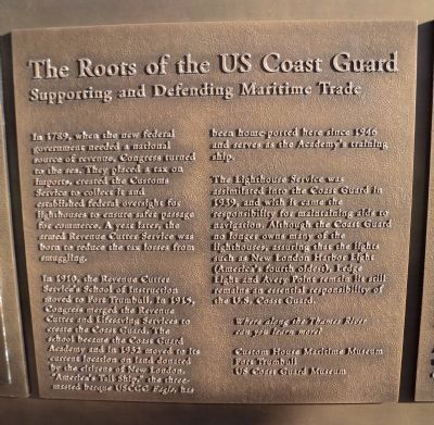
The Roots of the US Coast Guard
Supporting and Defending Maritime Trade
In 1789, when the new federal government needed a national source of revenue, Congress turned to the sea. They placed a tax on imports, created the Customs Service to collect it and established federal oversight for lighthouses to ensure safer passage for commerce. A year later, the armed Revenue Cutter Service was born to reduce the tax losses from smuggling.
In 1910, the Revenue Cutter Service’s School of Instruction moved to Fort Trumbull. In 1915, Congress merged the Revenue Cutter and Lifesaving Services to create the Coast Guard. The school became the Coast Guard Academy and in 1932 moved to its current location on land donated by the citizens of New London. “America’s Tall Ship,” the three-masted barque USCGC Eagle, has been home-ported here since 1946 and serves as the Academy’s training ship.
The Lighthouse Service was assimilated into the Coast Guard in 1939, and with it came the responsibility for maintaining aids to navigation. Although the Coast Guard no longer owns many of the lighthouses, assuring that the lights such as New London Harbor Light (America’s fourth oldest), Ledge Light and Avery Point remain lit still remains an essential responsibility of the U.S. Coast Guard.
Topics and series. This historical marker is listed in these topic lists: Industry & Commerce • Military • Waterways & Vessels. In addition, it is included in the Lighthouses series list. A significant historical year for this entry is 1789.
Location. 41° 21.26′ N, 72° 5.652′ W. Marker is in New London, Connecticut, in New London County. Marker is at the intersection of State Street and Bank Street, on the right when traveling west on State Street. Touch for map. Marker is in this post office area: New London CT 06320, United States of America. Touch for directions.
Other nearby markers. At least 8 other markers are within walking distance of this marker. The Atlantic Trade (here, next to this marker); The Amistad Incident (here, next to this marker); Native Americans (here, next to this marker); The Submarine Industry (here, next to this marker); The 19th Century Port (here, next to this marker); 54 State Street (a few steps from this marker); Revolutionary New London (within shouting distance of this marker); Revolutionary War Privateering (within shouting distance of this marker). Touch for a list and map of all markers in New London.
Credits. This page was last revised on May 6, 2023. It was originally submitted on October 14, 2011, by Bill Coughlin of Woodland Park, New Jersey. This page has been viewed 429 times since then and 11 times this year. Photos: 1, 2, 3. submitted on October 14, 2011, by Bill Coughlin of Woodland Park, New Jersey.


