Larkspur in Douglas County, Colorado — The American Mountains (Southwest)
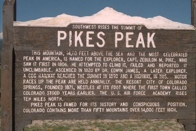
Southwest Rises The Summit of Pikes Peak
Inscription.
This mountain, 14,110 feet above the sea and the most celebrated peak in America, is named for the explorer, Capt. Zubulon M. Pike, who saw it first in 1806. He attempted to climb it, failed and reported it unclimbable. Ascended in 1820 by Dr. Edwin James, a later explorer. A cog railway reached the summit in 1890 and a highway, in 1915. Motor races up the peak are held annually. The resort city of Colorado Springs, founded 1871, nestles at its foot where the first town called Colorado stood years earlier. The U. S. Air Force Academy rises ten miles north.
Pikes Peak is famed for its history and conspicuous position. Colorado contains more than fifty mountains over 14,000 feet high.
Erected by Colorado Department of Highways.
Topics. This historical marker is listed in these topic lists: Exploration • Landmarks • Natural Features • Natural Resources. A significant historical year for this entry is 1806.
Location. 39° 13.792′ N, 104° 52.723′ W. Marker is in Larkspur, Colorado, in Douglas County. Marker is on Southbound Rest Area (Interstate 25 at milepost 171), in the median. Touch for map. Marker is in this post office area: Larkspur CO 80118, United States of America. Touch for directions.
Other nearby markers. At least 8 other markers are within 11 miles of this marker, measured as the crow flies. Old Stone Fort (approx. 9.1 miles away); The Rock / Gray Gold (approx. 9.9 miles away); Good Roads in Colorado / The Great North-South Highway (approx. 9.9 miles away); Keystone Hotel (approx. 10 miles away); Denver & Rio Grande Railroad Depot (approx. 10 miles away); City Hotel (approx. 10 miles away); Victoria’s House (approx. 10 miles away); Founders Village (approx. 10.3 miles away).
Also see . . .
1. Pikes Peak, America's Mountain. Pikes Peak Region Attractions website entry:
Information about the most visited mountain in North America. Pikes Peak is the farthest east of the big peaks in the Rocky Mountain chain. (Submitted on January 20, 2008, by Mike Stroud of Bluffton, South Carolina.)
2. Pikes Peak. Wikipedia entry:
The upper portion of Pikes Peak is a federally designated National Historic Landmark. (Submitted on January 20, 2008, by Mike Stroud of Bluffton, South Carolina.)
3. Pikes Peak Hill Climb Race. Wikipedia entry:
Drivers race up the mountain in a famous annual race called the Pikes Peak International Hill Climb. (Submitted on January 20, 2008, by Mike Stroud of Bluffton, South Carolina.)

J. J. Prats Postcard Collection
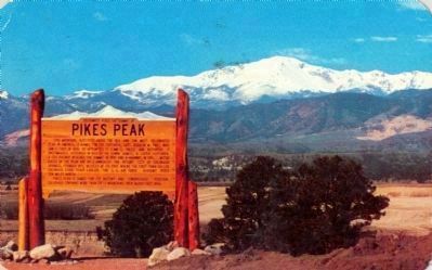
5. Pikes Peak Marker on a 1963 Postcard
Dexter (West Hyack, N.Y.) -brand postcard published by Sanborn Souvenir Co., Inc., Denver, Colorado. Caption reads “#3633 — Pikes Peak, alt. 14,100 ft. and historical marker on Hwy. 85 – 87 near the south entrance to the U. S. Air Force Academy.”
Credits. This page was last revised on January 9, 2022. It was originally submitted on January 20, 2008, by Mike Stroud of Bluffton, South Carolina. This page has been viewed 4,171 times since then and 18 times this year. Photos: 1, 2, 3, 4. submitted on January 20, 2008, by Mike Stroud of Bluffton, South Carolina. 5. submitted on September 10, 2009, by J. J. Prats of Powell, Ohio. • Kevin W. was the editor who published this page.


