Paducah in McCracken County, Kentucky — The American South (East South Central)
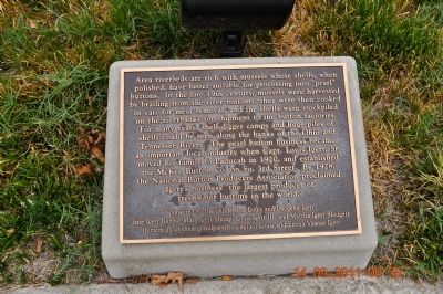
Area riverbeds
Erected by Sponsored by the children of Louis and Imogene Igert: Jan Igert Ranna, Mary Igert Shoup, Louis Igert III, Martha Igert Boldgett. In memory of their grandparents Captain Louis and Emma Vawter Igert.
Topics. This historical marker is listed in this topic list: Industry & Commerce. A significant historical year for this entry is 1920.
Location. 37° 5.264′ N, 88° 35.628′ W. Marker is in Paducah, Kentucky, in McCracken County. Marker is on South Water Street. Between Lock and Dam 52 and Paducah Marine Supply and Service. Touch for map. Marker is in this post office area: Paducah KY 42001, United States of America. Touch for directions.
Other nearby markers. At least 8 other markers are within walking distance of this marker. Paducah Marine Supply and Service (here, next to this marker); Lock and Dam 52 (here, next to this marker); Gen. George Rogers Clark (a few steps from this marker); Wheel Repair (a few steps from this marker); Paducah's Riverfront (a few steps from this marker); Construction in the 1840s (a few steps from this marker); Christening the Towboat Eleanor (a few steps from this marker); May 1913 Paducah Homecoming (a few steps from this marker). Touch for a list and map of all markers in Paducah.
Also see . . . Mussels. The common name mussel is used for members of several families of clams or bivalvia mollusca, from saltwater and freshwater habitats. These groups have in common a shell whose outline is elongated and asymmetrical compared with other edible clams, which are often more or less rounded or oval. (Submitted on November 5, 2011, by Sandra Hughes Tidwell of Killen, Alabama, USA.)
Credits. This page was last revised on June 16, 2016. It was originally submitted on November 5, 2011, by Sandra Hughes Tidwell of Killen, Alabama, USA. This page has been viewed 996 times since then and 36 times this year. Photos: 1, 2. submitted on November 5, 2011, by Sandra Hughes Tidwell of Killen, Alabama, USA. • Craig Swain was the editor who published this page.

