Tangipahoa in Tangipahoa Parish, Louisiana — The American South (West South Central)
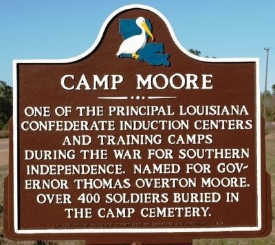
Camp Moore
Erected 1959 by Louisiana Department of Commerce and Industry.
Topics. This historical marker is listed in this topic list: War, US Civil.
Location. 30° 53.063′ N, 90° 30.711′ W. Marker is in Tangipahoa, Louisiana, in Tangipahoa Parish. Marker is on U.S. 51, on the right when traveling north. Touch for map. Marker is in this post office area: Kentwood LA 70444, United States of America. Touch for directions.
Other nearby markers. At least 8 other markers are within walking distance of this marker. Camp Moore #1 (about 300 feet away, measured in a direct line); Camp Moore Confederate Cemetery (about 400 feet away); Camp Moore #6 (about 500 feet away); Camp Moore #2 (about 600 feet away); Camp Moore #5 (about 700 feet away); a different marker also named Camp Moore (approx. 0.2 miles away); Camp Moore #3 (approx. 0.2 miles away); Camp Moore Confederate Soldiers Memorial (approx. 0.2 miles away). Touch for a list and map of all markers in Tangipahoa.
Credits. This page was last revised on June 16, 2016. It was originally submitted on November 24, 2011, by Jeff Lovorn of Florence, Mississippi. This page has been viewed 747 times since then and 16 times this year. Photos: 1. submitted on November 24, 2011, by Jeff Lovorn of Florence, Mississippi. 2. submitted on January 23, 2016. • Craig Swain was the editor who published this page.
Editor’s want-list for this marker. A wide view photo of the marker and the surrounding area in context. • Can you help?

