Near Middletown in Frederick County, Virginia — The American South (Mid-Atlantic)
Battle of Cedar Creek

Photographed By Roger Dean Meyer, June 3, 2006
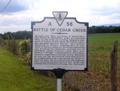
1. Battle of Cedar Creek Marker
A Virtual Tour of the Battle of Cedar Creek by HMDb Markers
Click for more information.
Click for more information.
In early Oct. 1864, portions of Union Maj. Gen. Philip H. Sheridan’s army bivouacked here on the hills and rolling farmland just north of Cedar Creek along the Valley Turnpike (present-day U.S. Rte. 11). Just before daybreak on 19 Oct., Confederate Lt. Gen Jubal A. Early’s infantry divisions surprised and attacked the Federals, routing two of Sheridan’s three infantry corps. Maj. Gen. Horatio G. Wright, commanding in Sheridan’s absence, organized a retreat north. Sheridan arrived on the battlefield from Winchester by midmorning and rode along the front to rally his men. By late afternoon the Federals had counterattacked Early’s left front and crushed the Confederate troops, who fled south.
Erected 2000 by Department of Historic Resources. (Marker Number A-56.)
Topics and series. This historical marker is listed in this topic list: War, US Civil. In addition, it is included in the Virginia Department of Historic Resources (DHR) series list. A significant historical year for this entry is 1864.
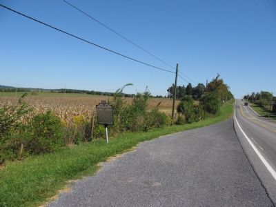
Location. 39° 0.829′ N, 78° 18.194′ W. Marker is near Middletown, Virginia, in Frederick County. Marker is on Valley Pike (U.S. 11) 0.2 miles south of Belle Grove Road, on the right when traveling south. Touch for map. Marker is in this post office area: Middletown VA 22645, United States of America. Touch for directions.
Other nearby markers. At least 8 other markers are within walking distance of this marker. Eve of Battle (here, next to this marker); a different marker also named The Battle of Cedar Creek (about 600 feet away, measured in a direct line); Ramseur Monument (about 700 feet away); a different marker also named Eve of Battle (approx. 0.2 miles away); Stand of the Eighth Vermont (approx. 0.2 miles away); Cedar Creek (approx. 0.2 miles away); Slowing the Advance (approx. 0.2 miles away); The Shenandoah Valley / Battle of Cedar Creek, October 19, 1864 (approx. 0.2 miles away). Touch for a list and map of all markers in Middletown.
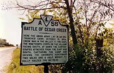
More about this marker. This marker replaced the original A-56 marker originally erected in the 1940s with the same title. That marker read “Here the Union army lay in an entrenched camp, October 19, 1864. Crook was in the valley to the east; the Nineteenth Corps on the hillside facing south. At dawn the Confederates attacked from the east and south, capturing the camp and driving the Unionists northward two miles and a half. Wright finally halted the retreat.”
Regarding Battle of Cedar Creek. The Cedar Creek battlefield is interpreted by several markers. See the Battle of Cedar Creek Virtual Tour by Markers link above.
Also see . . .
1. Battle of Cedar Creek. National Parks Service summary of the battle. The action mentioned on the marker is discussed as phase 4 of the battle. (Submitted on September 30, 2007, by Craig Swain of Leesburg, Virginia.)
2. The Battle of Cedar Creek during the Civil War in the Shenandoah Valley. Some battle details, maps and a number of photos of the area, good for a driving tour (Submitted on March 24, 2010, by Hal F. Sharpe of Edinburg, Virginia.)

Photographed By Craig Swain, September 29, 2007
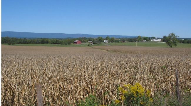
4. Belle Grove and Grounds
In the distance is Belle Grove, a landmark of the battlefield. In the morning phase of the battle, elements of Crook's and Emory's Federal Corps fell back from their camps through the fields in the foreground. The retreat quickly became a route, followed up by Gordon's Confederate Division. Gordon's troops would press the Federals past Meadow Creek, flowing behind Belle Grove to the northwest.
Credits. This page was last revised on June 30, 2022. It was originally submitted on October 5, 2006, by Roger Dean Meyer of Yankton, South Dakota. This page has been viewed 2,825 times since then and 36 times this year. Last updated on December 9, 2011, by Don Hogan of Milton, Georgia. Photos: 1. submitted on October 5, 2006, by Roger Dean Meyer of Yankton, South Dakota. 2. submitted on November 20, 2008, by Mike Stroud of Bluffton, South Carolina. 3, 4. submitted on September 30, 2007, by Craig Swain of Leesburg, Virginia. • Craig Swain was the editor who published this page.

